Bentley lowers cost without sacrificing functionality
1 June 2004

Bentley Systems has brought three powerful new tools to market for those professionals who do not need the full feature set of MicroStation but who do not want to sacrifice functionality with a less comprehensive product. Bentley PowerMap provides engineers an easy-to-use, 2D editing environment to complement geospatial projects built on MicroStation and MicroStation GeoGraphics. Bentley PowerSurvey provides survey professionals with an `all-in-one' solution for survey data management and drafting. Compatible with both the GEOPAK and InRoads families of civil solutions, it includes a full complement of survey adjustment, digital terrain modelling, notation and drafting tools. Bentley PowerCivil is a multidiscipline product for survey, graphical coordinate geometry (COGO), digital terrain modelling, site grading, water and sewer, and storm drainage and street design.
Bentley PowerMap
This new release is Bentley's premier data access and decision support application for geospatial solutions and is the migration/upgrade path from MicroStation GeoOutlook for existing select subscribers.
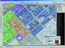
Bentley PowerMap supports the simultaneous viewing (2D and 3D data) and plotting of vector and raster data. The tools for seamless map display, features display, thematic mapping and analysis are all equal to their counterpart found in MicroStation GeoGraphics. Geospatial information created with Bentley PowerMap can directly, without translation, be used in MicroStation and MicroStation GeoGraphics.
The software provides read/write access to ODBC-connected databases, further enhancing mapping environments. Users can also query Oracle Spatial data to support the use of enterprise data in their mapping workflows. Also supported is querying of data stored in Oracle 8i Spatial and Oracle 9i spatial/locator.
The analysis tools include polygon overlay and network analysis such as shortest path. Workflows, with focus on geospatial data distribution, can be customised with the same programming environment as MicroStation and MicroStation GeoGraphics by using MDL, VBA, JMDL and MicroStation basic.
Bentley PowerSurvey
The software processes survey data and outputs results in the two leading engineering formats - DWG and DGN. This cost-effective tool with a minimal learning curve is an excellent fit for surveying consultancies of any size.
Bentley PowerSurvey provides surveying professionals with a complete set of survey-specific tools for both Bentley's InRoads and GEOPAK product suites. It directly processes the data from a field-surveying device and automatically displays the resulting graphics onscreen. Users can then manipulate the data using the editing, reduction and adjustment tools.
The software communicates with all industry-leading data collectors. Connect a data collector directly to a personal computer, laptop or tablet PC and use PowerSurvey to manage the survey data. PowerSurvey can also upload GEOPAK or InRoads data to the data collector for field stakeout procedures.
Bentley PowerSurvey supports extensive feature databases that detail the representation of each survey shot or feature, including symbolisation, labelling, DTM control, and more. The feature database is completely user-definable and ensures standardisation from the field surveyor to designer.
Bentley PowerCivil
The software is a low-cost solution for land development and site modelling. Bentley PowerCivil provides comprehensive design capabilities and offers civil engineers a flexible 2D/3D tool without requiring a CAD software platform.
PowerCivil is unique, offering a comprehensive civil engineering workflow solution that includes relationship modelling. The modelling capabilities enable rapid, dynamic exploration of site development scenarios. Design alternatives can be readily explored with clients and contractors through quick visual modifications. The end results are reduced risk and improved constructability of designs.
As an integrated, multidiscipline product for survey, graphical coordinate geometry (COGO), digital terrain modelling, site grading, water and sewer, and storm drainage and street design, PowerCivil builds on Bentley's market leading solutions. It can be used for a wide range of projects including commercial building, plant and manufacturing sites; airports and rail terminals; subdivisions, urban complexes, parks and golf courses; dams, mines and landfills; and drainage, utility and floodplain projects.
For more information contact Bentley Systems, 011 462 5811, www.bentley.com
Others who read this also read these articles
A challenge for motor manufacturers
Computer-based integration of design and manufacturing is essential for the '24-month car' to be achieved[ October 2004 ]
Prominent new lifestyle centre for Cape Town's financial district
Dimension Modeling created the 3D interior models that were then also rendered out for internal views of the apartments as well as the atrium and foyer areas[ August 2004 ]
Anglo Platinum - automating repetitive design tasks with Solid Edge
Solid Edge Insight is an innovative solution that seamlessly integrates CAD, design management and Web-based collaboration into a single tool that is easy to implement and easy to manage[ June 2004 ]
Styled plastic products and packaging - main pains and solution initiatives
To put the product and the customer front and centre, where they belong, all disciplines must sit at the same virtual table, sharing the same information and seeing the same vision[ June 2004 ]
Evolution from 2D to 3D - a product development manager's perspective: Part II
Whereas 2D CAD shortens time scales to some extent, 3D CAD goes much further, directly supporting the whole product development cycle, speeding up every activity and increasing the quality of design by removing many sources of inaccuracy and error[ April 2004 ]
Multiphysics analysis to simulate cylinder head
Adiabatics Inc used multiphysics FEA software from Algor to study the thermal and structural behaviour of a cylinder head for a diesel engine that would provide reduced heat rejection and increased power density while maintaining its superior fuel economy and lower operating cost[ December 2003 ]
Unigraphics NX 2: the next generation
What the NX 2 release sees is the integration of the use of networks of curves to define surface boundaries and existing geometry, and freeform surface modelling into the core of Unigraphics but with a few rather neat extras as well[ October 2003 ]
Geopak helps create Festival City
Geopak Site allows one to handle with ease live 'what if' scenarios with the client and other design team members[ August 2003 ]
Others who read this also read these news items
Lockheed Martin selects preferred MCAD tool
[ December 2005 ]
Grand scale initiatives at Ethekwini Municipality
[ October 2005 ]
Robert Mugabe Avenue in Windhoek gets extension
[ August 2005 ]
Strand7 nonlinear analysis used to solve bracket deformation problem
[ August 2005 ]
Scania optimises truck components
[ February 2005 ]
Delcam's PowerMILL chosen for A1 Grand Prix engine manufacture by Zytek
[ February 2005 ]
A first of its kind: irrigation development, a R3,7-billion SADC project
[ February 2005 ]
Arup lands Tianjin Olympic Aquatic Centre project
[ December 2004 ]
Others who read this also read these regulars
Search Site
Subscribe
Previous Issues
Other Technews Publications
Other Technews Buyers Guides
 |  | Copyright c1995-2009 Technews Publishing (Pty) Ltd.. All rights reserved. |