Shuttle mission begins its ambitous map of the world
February 2001
Philip Chien
The longest rigid structure in space was recently deployed as part of an effort to map almost all of the populated areas of the world in three dimensions
Space Shuttle Endeavour was launched on Friday 11 February at 12:44 pm EST on an ambitious 11-day mapping mission. Sitting in the shuttle cargo bay is the largest radar system ever put in to space. Most of the hardware flew previously on a pair of Space Radar Laboratory missions in 1994. During those flight multiple pass interferometry was tried as an experiment, electronically combining the radar images from two separate passes over a region to produce a three dimensional topographical map. But that technique could only work for limited areas of interest.
The US Defense Department had a requirement to map as much of the world as possible in three dimensions. Obvious tactical applications include terrain maps for cruise missiles and better pre-battle flight simulators for fighter pilots flying in to enemy territory. The data also has commercial applications ranging from where to place cellular telephone towers to planning the impact of how a new dam changes an area's drainage system.
NASA's Jet Propulsion Laboratory recommended reflying the existing Space Radar Laboratory hardware with an important addition, a second receive-only antenna positioned a fixed distance from the shuttle for single pass interferometry. The dual antennas act like stereo vision generating different phases which are combined through software to generate the three dimensional image. The most practical way to fly a separate antenna in formation with the shuttle is with an extendible mast. Similar smaller booms have been used for previous shuttle experiments and are planned for the International Space Station's solar arrays. SRTM's 60 m mast is twice as long as the previous record for an extended object in space. The mast's clever design enabled it to be compressed in to a canister just one-twentieth its extended length. Technical specifications for the mast can be found at: www.aec-able.com/corporate/srtm_ spex.htm
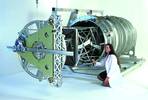
SRTM Mast - flight hardware with first few bays deployed, with member of ABLE's SRTM team
That long a boom is both a technical and safety challenge. From a technical point-of-view it has to be extremely stiff, and have an extremely low coefficient of thermal expansion. In many ways it is similar to maneouvering any long object, you have got to make extremely careful small movements to avoid letting it get away from you. From a safety point-of-view anything that extends over the side of the shuttle's cargo bay has to have an emergency jettison capability in case the shuttle has to return to Earth quickly.
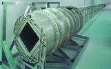
SRTM Mast - flight hardware fully deployed, shown from canister end
The boom defied its critics and came out incredibly smoothly on time. It started expanding at 6:27 pm EST as Endeavour was travelling over Southeast Australia and completed its task 18 minutes later. After extending the boom and locking the second antenna in place the astronauts performed a set of calibration tests firing the shuttle's small thrusters with and without the boom's dampers activated to verify that the calculated mechanical characteristics matched what was actually occurring in space.
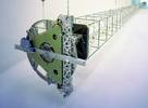
SRTM Mast - flight hardware fully deployed, shown from tip end
Based on the data collected during the on-orbit tests the shuttle's computerised attitude control system was programmed to disable any commands that would cause the mast to vibrate at any of its natural harmonic or resonant frequencies.
By 12:32 am, 11 h and 47 min after the shuttle's launch it was ready to begin mapping the world. At this point the shuttle was on its ninth orbit, travelling over the Maldives Islands in the Indian Ocean. Over the next ten days the SRTM payload mapped over 72% of the world's land areas, encompassing over 95% of the world's population.
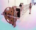
SRTM Mast - flight hardware fully deployed, shown from tip end with members of ABLE's SRTM team
Note: the author is a full-time aerospace writer covering the space shuttle and other aspects of the space programme with over 15 years of experience.
Article used with permission of SpatialNews.com and The Geocommunity written by Philip Chien
Contact: Glenn Letham
(09) 1 850 897 0110
Why Use Radar?
Have you ever seen a map that shows not only the location of features on the Earth, but also how high or low they are? This information is known as topography, and maps which display elevation information are called topographic maps.
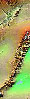
Images taken by the radar mapping system
There are lots of ways that people make use of topographic data. Scientists use information about topography to help in their studies of plants and animals. Elevation information provides clues about soil types, and can tell you how the surface of the Earth changes due to the actions of glaciers, rivers, and the processes of mountain building and erosion. City planners use topographic data to help locate suitable places for structures or recreation. Aircraft pilots require accurate topographic information for flight planning and navigation, and the military requires precise topographic information for training and realtime operations. Knowing the exact height and location of mountain peaks enables the cellular phone industry to place towers in optimal locations for signal reception. In addition, topographic maps are the mainstay of day hikers and weekend backpackers.
For various parts of the world, maps of the Earth's topography are limited, inaccurate, or nonexistent. For example, many mountain chains, inhospitable deserts, and dense tropical rain forests have topographic coverage that is totally inadequate mainly because of the difficulty in getting to these locations. Even where topographic maps exist, they may have been created in such a way as to limit their usefulness. Neighbouring countries may generate topographic data using entirely different methods. This lack of standardisation effectively limits the scope of regional or global studies where precise topography is important.
The Shuttle Radar Topography Mission (SRTM) will use radar instruments to collect data for the most detailed, near global topographic map of the Earth ever made.
For this application, radar is a better tool to use than regular optical cameras because it can operate day or night and can penetrate cloud cover. Flying the radar on the Shuttle means that physical access to a site is no longer a problem.
Using the technique of interferometry, SRTM will collect data over 80% of Earth's land mass, home to nearly 95% of the world's population. All of the radar data will be collected during a single, 11-day Space Shuttle mission, and will be processed to the same specifications. Collecting and processing the data this way ensures that the SRTM generated topographic maps will have the same characteristics.
The information collected by SRTM will be used to provide a tool to enhance the activities of scientists, the military, commercial, and civilian users.
Others who read this also read these articles
Automotive and Aerospace Tooling Seminar
'Innovation' was the main topic of the seminar[ October 2005 ]
INSITE
South Africa's first, new International Science, Innovation & Technology Exhibition (INSITE) will showcase those ideas, innovations, products, technologies, services and solutions that are set to drive South Africa and the rest of the world forward into the future[ August 2004 ]
FM top 100 websites that save you time and money
Win HP products worth R20 000[ June 2004 ]
New search facility on cgweb.co.za
Technews has announced that the search engine on all its online magazines has undergone a radical upgrade.[ August 2003 ]
Championship winners use FEA for design optimisation
Algor's InCAD technology provides direct CAD/CAE data exchange and full associativity with each design change for Autodesk Inventor, which Morton uses when modelling load-bearing components[ June 2003 ]
Indigenous design key for manufacturing sector growth
Visionary development programmes, implemented by the South African Institution of Mechanical Engineering, are helping to foster interest in technology among school level learners[ April 2003 ]
Computers - how do they affect your eyesight?
There is now medical evidence that using display screen equipment is not associated with damage to eyes or eyesight, nor makes existing defects worse[ February 2002 ]
New product releases well received at European Catia Forum
Eight of the 11 Formula One teams use Catia for either chassis or engine design[ December 2000 ]
Others who read this also read these news items
Breakfast with Clem Sunter and the JCCI
[ December 2005 ]
SABS disa product design award scheme calls for entries
[ December 2005 ]
Software for crash simulation
[ December 2005 ]
New appointment
[ December 2005 ]
Free downloads a success
[ December 2005 ]
Graficomp wins international award
[ December 2005 ]
Epson SA's channel partners recognised at annual awards
[ October 2005 ]
Free software download
[ October 2005 ]
Others who read this also read these regulars
Everest - getting better all the time
[ December 2005 ]
Roland inspiring creative people in every industry
[ August 2005 ]
The four pillars of Bentley
[ December 2003 ]
Bullish Bentley takes plant market by storm
[ February 2003 ]
Enterprise Engineering in transportation and civil engineering
[ October 2002 ]
Search Site
Subscribe
Previous Issues
Other Technews Publications
Other Technews Buyers Guides
 |  | Copyright c1995-2009 Technews Publishing (Pty) Ltd.. All rights reserved. |