Sustainable fisheries and marine conservation in Kenya
August 2002
Simon Jennings, Sangunra Consultants
Kiunga Marine National Reserve, on Kenya's northern coast, protects outstanding mangrove forests, sea grass beds and coral reefs. Its beaches provide nesting sites for marine turtles, and its sea grass beds feeding grounds for the enigmatic dugong. Its offshore rock formations shelter bat roosts and support the world's largest nesting colony of roseate terns, and sharks, rays, whales and dolphins occur further out to sea. Tidal creeks, limpid lagoons and towering dunes enrich the landscape.
Much of Kenya's coast has experienced rapid human population growth, spiralling demand for marine resources and unplanned development. Unregulated harvesting of fisheries and forests have outstripped rates of natural renewal, while discharges of domestic and industrial waste have overwhelmed the capacities of intertidal wetlands to absorb, dilute and detoxify effluents.
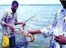
Kiunga’s lobster divers use the kimia technique to catch lobsters
Kiunga has survived intact mainly because of its remoteness. Most of the Bajuni people living around the Reserve earn their living from fishing. Traditionally they used woven traps to catch reef fish in shallow waters. Mzee Abbas is one of the few remaining practitioners of the technique. "I have always used the uzio and malema traps, and cannot see the need to change," he says.

Mzee Abbas makes traps
But most fishermen today use highly effective, and destructive, seine nets. These catch all fish size-classes indiscriminately and damage corals and sea grass beds. Larger-meshed gill nets are also used - though less damaging to the substrate, they entangle and drown turtles and dugongs. Kiunga's lobster divers use the kimia technique, in which the fisher spears an octopus and ties it to his spear. Lobsters shelter in the reefs in holes with an exit route, so the diver places his hand-net over the back door and waves the octopus at the front - the lobster heads for the emergency exit and ends up in the net. Increasingly smaller lobsters are being taken on the reefs, including gravid females.
External pressure, is intensifying on Kiunga. 60% of users come from outside the reserve and there is growing demand from commercial outfits interested in 'mining' the fishery. Habitat damage and declining catches already are apparent: left unchecked, they will diminish the biological value of the reserve and impoverish the people most dependent upon it.
Fisheries management strategy in Kiunga
A fear expressed by Kiunga fishers is that 'effective management of the fishery' means 'reduced income for fishermen'. To address these concerns, World Wide Fund for Nature is facilitating a joint effort with all stakeholders towards:
* Objective appraisals of the fishery in biological and socio-economic terms.
* Clear identification of threats to fishery sustainability.
* Agreements on management interventions needed for sustainability.
* Pilot-testing of interventions.
* Monitoring to track the performance of the interventions.
* Mechanisms to disseminate information to all the stakeholders.
* Clear identification of threats to fishery sustainability.
* Agreements on management interventions needed for sustainability.
* Pilot-testing of interventions.
* Monitoring to track the performance of the interventions.
* Mechanisms to disseminate information to all the stakeholders.
ArcView GIS in fishery management information systems
The first step in this strategy outlined above implies various questions:
* Is offtake going up or down?
* Is offtake sustainable?
* How is offtake being acquired - eg gears?
* How are benefits being shared between stakeholders?
* What do the trends suggest is happening to the fishery?
* Do we need to do anything about it?
* Is offtake sustainable?
* How is offtake being acquired - eg gears?
* How are benefits being shared between stakeholders?
* What do the trends suggest is happening to the fishery?
* Do we need to do anything about it?
WWF-trained community monitors have been collecting data on fish and lobster harvests since 1998, but financial constraints hampered the project's ability to use the data acccumulated. Now a Microsoft Access database is being developed to manage the data. This will provide the flexible automated analyses to explore the key issues of concern.
An ArcView GIS is being set up to augment the fisheries database. GIS's role will be to communicate outputs from the fisheries database. Connectivity between ArcView and Access is therefore an important asset. Our level of use is very simple - with everything on one PC we rely on ArcView SQL Connect and database table linking and joining to access fisheries data in the database. Should we scale up the system we can take advantage of ArcView's Database Access, SDE and ODBC connection facilities.
Any fisheries data analyses with a spatial element, eg catch per fishing ground, relations between habitat health and gear use, etc, can be linked to the GIS. This is helpful for presentations at fisheries management meetings - displaying such relationships on maps makes them more explicit. For all audiences, it helps if the results can be fitted to a mental map - the "Yes, but where is it?" factor - that satisfactorily clarifies the issues. We find the process of development of resource maps an excellent way of involving local fishers in planning resource use.
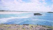
Kiunga view
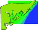
Development of the WWF Kiunga GIS
The GIS has been set up with ArcView V. 3.2. We have used image analyser to manipulate and georectify graphical background themes; and employed 3D Analyst to create and view TINS that provide a conceptual three-dimensional representation of the fishery (see graphic). Themes include the basic outlines of coastal and island land forms; key locations and fishing grounds, tracks and seafloor contours. Data was sourced from topographical maps, nautical charts, scanned graphics and GPS.
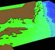
Kiunga 3D view
More GPS work will provide ground control points with which we can refine and classify landscape themes, and complete data on fishing grounds, or imbos. From May-September the south-east monsoon makes offshore conditions too rough for small craft, so we have concentrated on mapping imbos lying within the reefs. These are sheltered from the open sea but still experience tumultuous surf - quite a distraction to survey work for those of us more used to dry land! Back on terra firma, GPS data are downloaded through Garmin's MapSource program; then converted to point shapefiles with ArcView's AddEventTheme protocol.
WWF recently commissioned aerial photography of the Kiunga area and once the photos have been mosaiced we will incorporate them in the GIS, manipulating them with Image Analyser. We expect that this theme will permit detailed land cover classification. We are also investigating satellite imagery that can resolve features in 3-5 m water depth. This has been done (SPOT) in Mauritius (advice from readers on remote sensing in marine environments would be appreciated).
The GIS will permit increasingly revealing spatial analyses of the ecology of the reserve. Obvious options are habitat associations, occurrence maps and ranging models for species of concern (eg with Spatial Analyst), detailed maps of sensitive sites, sampling sites and habitats under restoration. The GIS could also be used to undertake change assessments of the productivity of fishing grounds, coral reefs, recovering habitats, and nesting beaches.
For more information: GIMS, 011 695 0400.
Others who read this also read these articles
An intelligent, integrated approach
MapIT has crafted a Licensed Partner programme based on the common requirement for highly accurate mapping data[ October 2004 ]
Picture it ...
MarketScope can calculate virtually any demographic scenario for your marketplace, taking into account a variety of factors, including your customer profiles, census information, competitor analysis data and any other set of business-related statistics you wish to evaluate, and visually display the results, arriving at an answer within 30 seconds[ August 2004 ]
Mondi develops advanced GIS business system
Mondi Forests has a truly integrated GIS business system that not only takes care of daily operational requirements, but also facilitates the use of GIS decision-making technology[ June 2003 ]
Implementation of a GIS system in local government
The most cost effective and user friendly way of implementing the MIS system and making it accessible to all authorised officials and Councillors throughout the Municipality was to build a Web application using Bentley Publisher[ April 2003 ]
GIS technology saluted for social and economic contributions
GIS is a powerful analytical tool that integrates spatial (or location) data with associated information, presenting the result in an easy-to-understand, map-based format[ February 2003 ]
ArcGIS Schematics launched
ArcGIS Schematics offers a high degree of flexibility and is not limited by the evolution of the data model and by changing database locations[ February 2003 ]
Building a locations-based service
Before we can start any project, we need to know and understand what the system is going to be used for[ August 2002 ]
Calling the competitive shots
“The solution has given us a competitive differentiator which has proved to be a very impressive revenue generator.”[ June 2002 ]
Others who read this also read these news items
Hikers, bikers and urban street pioneers
[ December 2005 ]
Image compression provides post-Katrina aerials within days
[ December 2005 ]
Navigation - the tip of the GIS iceberg
[ October 2005 ]
Fun and affordable in-car navigation
[ October 2005 ]
Cycling on the edge
[ October 2005 ]
Routing made easy
[ August 2005 ]
MapIT expands into West Africa
[ August 2005 ]
Incredible Connection powers navigation tools
[ August 2005 ]
Others who read this also read these regulars
ArcIMS 9.1 Route Server - routing and geocoding
[ October 2005 ]
Enterprise GIS with ArcGIS 9: a comprehensive GIS platform
[ October 2004 ]
GIS in Africa
[ August 2003 ]
Complete logistics and routing solution
[ August 2002 ]
ESRI offers highly integrated GIS solutions
[ April 2002 ]
GIS - the tool to help manage change in the 21st century
[ April/May 2000 ]
GIS software that sets a new standard
[ April/May 2000 ]
Search Site
Subscribe
Previous Issues
Other Technews Publications
Other Technews Buyers Guides
 |  | Copyright c1995-2009 Technews Publishing (Pty) Ltd.. All rights reserved. |