Implementation of a GIS system in local government
April 2003
“Money is the life blood of any municipality”, says Tex van Deventer, managing director of Bentley Systems. “And if your GIS system does not work hand in hand with your business systems, a great opportunity to properly control the critical area of revenue management is going amiss.”
In December 2000, the Emalahleni Municipal Council identified a number of factors as being important contributors to the loss in income in certain towns from the sale of electricity and other services.
Consumer metering installations were not functioning properly, mainly because pre-paid electricity meters were being tampered with, by-passed, and damaged in large numbers. With conventional electricity meters not always being sealed, accuracy was also questionable. And many buried water meters proved impossible to read.
Problems did not only exist on the procedural side. The consumer database information in the financial system differed in many cases with the data according to the surveyor general's layout plans. There were also pre-paid consumers who had electricity connections without being registered as a consumer by Council. The overall picture was fairly chaotic. The Management Information extracted and supplied to Council and officials was inaccurate and delayed so that no sensible decisions could be taken on the basis of this information.
Proposed solution
The Council turned towards Utility Information Systems as consulting engineers and GRID as the Bentley and IT consultants to find a suitable solution. A multidimensional solution was called for in order to rectify the many aspects of the situation as described above. Fortunately Council recognised the problems for what they were and accepted a proposal to address these to their full extent. The solution involved addressing both procedures and data integration from the various systems, the first step being the normalization of the procedures surrounding the handling of installations, tampering, by-passing and, damaging of meters in order to have a consistent rule base.
Following on this was the implementation of a Revenue Management Process, so structured as to maintain the normalised metering process, monitor and analyse various performance criteria with the aim of identifying ways in which to reduce losses and increase income, setting up a formalised structured process for conventional meter readings and verification of readings and, setting up procedures for the cut-off, reconnection, follow-ups and prosecution of consumers in arrears with services payments.
With these in place, the next step was to set up a Management Information System on the Collaborative Engineering Principle where the database information of the Finance Department could be analysed alongside the database information from Engineering, Town Planning and other departments. This then needed to be made available to all authorised levels of management within the organisation.
The management information system (MIS)
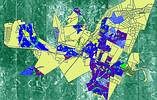
The creation of a meaningful GIS-based Management Information System meant several areas had to be addressed. Bentley MicroStation was used to capture and prepare GIS drawings for the whole of the demarcation area, starting with Kwa-Guqa.
Using MicroStation GeoGraphics, all consumers were identified, isolated and coordinated with the Surveyor General's maps of the area and on the prepared GIS drawings. This was then linked to the financial database and the pre-paid Master Station database through unique identifiers, thus enabling creative use of thematic queries based on financial and transaction information.
The whole data clean-up exercise was extended to include the capture of other valuable consumer information and linking this to the GIS data. Such information would facilitate exercises such as determining typical consumption within certain income groups, thus facilitating future infrastructure planning and providing a baseline against which potential problem consumers could be identified.
Using the Web
The most cost effective and user friendly way of implementing the MIS system and making it accessible to all authorised officials and Councillors throughout the Municipality was to build a Web application using Bentley Publisher. This included the development of queries and the development of reports, graphs and statistics required for Revenue Management.
Interviews were held with all departmental heads and personnel and joint application development (JAD) sessions were initiated to determine departmental requirements and to establish database connectivity with other database information contained in computers elsewhere in the Municipality, the database on indigents being a perfect example of this.
Once all these steps were taken and the Web interface had been developed on top of the GIS model in Microstation GeoGraphics the model was now ready for Bentley Publisher. This Web interface interlinked with the GIS engine to do searches for consumers on the Web, checking the attribute data and plotting them on a GIS map through the Web. Running queries on low payers, no payers and land information made this system unique and management thereof a step closer to real world solutions.
On the cards for the near future is a Web portal where municipalities like Emalahleni and others will be able to log in and use the system without investing in expensive hardware and software, but being able to manage their own data on the Web. This portal would bring Local Government closer to viable solutions and bring companies that participate in the broader management process closer to each other through a common data source. Initial work in this regard can be viewed at www.munispace.com
For more information contact Bentley Systems South Africa, 011 462 5811.
Others who read this also read these articles
An intelligent, integrated approach
MapIT has crafted a Licensed Partner programme based on the common requirement for highly accurate mapping data[ October 2004 ]
Picture it ...
MarketScope can calculate virtually any demographic scenario for your marketplace, taking into account a variety of factors, including your customer profiles, census information, competitor analysis data and any other set of business-related statistics you wish to evaluate, and visually display the results, arriving at an answer within 30 seconds[ August 2004 ]
Mondi develops advanced GIS business system
Mondi Forests has a truly integrated GIS business system that not only takes care of daily operational requirements, but also facilitates the use of GIS decision-making technology[ June 2003 ]
GIS technology saluted for social and economic contributions
GIS is a powerful analytical tool that integrates spatial (or location) data with associated information, presenting the result in an easy-to-understand, map-based format[ February 2003 ]
ArcGIS Schematics launched
ArcGIS Schematics offers a high degree of flexibility and is not limited by the evolution of the data model and by changing database locations[ February 2003 ]
Building a locations-based service
Before we can start any project, we need to know and understand what the system is going to be used for[ August 2002 ]
Sustainable fisheries and marine conservation in Kenya
A Microsoft Access database is being developed to manage the data[ August 2002 ]
Calling the competitive shots
“The solution has given us a competitive differentiator which has proved to be a very impressive revenue generator.”[ June 2002 ]
Others who read this also read these news items
Hikers, bikers and urban street pioneers
[ December 2005 ]
Image compression provides post-Katrina aerials within days
[ December 2005 ]
Navigation - the tip of the GIS iceberg
[ October 2005 ]
Fun and affordable in-car navigation
[ October 2005 ]
Cycling on the edge
[ October 2005 ]
Routing made easy
[ August 2005 ]
MapIT expands into West Africa
[ August 2005 ]
Incredible Connection powers navigation tools
[ August 2005 ]
Others who read this also read these regulars
ArcIMS 9.1 Route Server - routing and geocoding
[ October 2005 ]
Enterprise GIS with ArcGIS 9: a comprehensive GIS platform
[ October 2004 ]
GIS in Africa
[ August 2003 ]
Complete logistics and routing solution
[ August 2002 ]
ESRI offers highly integrated GIS solutions
[ April 2002 ]
GIS - the tool to help manage change in the 21st century
[ April/May 2000 ]
GIS software that sets a new standard
[ April/May 2000 ]
Search Site
Subscribe
Previous Issues
Other Technews Publications
Other Technews Buyers Guides
 |  | Copyright c1995-2009 Technews Publishing (Pty) Ltd.. All rights reserved. |