ESRI offers highly integrated GIS solutions
1 April 2002
ESRI has pioneered the development and use of GIS technology for over 32 years, and is noted for providing highly integrated GIS solutions to its clients. The company's open GIS solutions support a variety of enterprise implementation solutions for hardware and software systems as well as existing data environments.
ESRI is committed to providing open access to data and geoprocessing capabilities through a clearly defined and coordinated series of actions. These include open data interchange, open platforms, open development environments, open databases, open tools, and open application program interfaces (APIs).
ESRI is also the first GIS software company to build a true component-based GIS architecture when it built ArcGIS using a very fine level of granularity supporting object component technology. This has resulted in more flexible, smaller, and faster products.
The key GIS software integration premise behind this enterprise architecture can be summarised in two main points viz open development environment for enterprise integration, and continuous support for industry standards.
With these key points, users are able not only to use most current and powerful GIS software but also to integrate various legacy data sets. Users can also take advantage of the next generation of GIS and nonGIS software that integrates data at the desktop. ESRI's product architecture for the enterprise GIS closely follows the principles of the Open GIS specifications in development by the Open GIS Consortium (OGC), demonstrating its commitment to integrating enterprise-wide information and geospatial applications. In fact, ArcSDE was the first application to be certified compliant by OGC in March 1999 (see www.opengis.org/techno/conformance.htm#products).
Open development environment
An open development environment is vital for enterprise-wide geospatial systems for two main reasons. First, use of proprietary and little used development environments make it very difficult to interface geospatial applications, geoprocessing services, and geodata with other nonGIS applications and databases. Second, application development is widely known to be one of the most time-consuming and, therefore, expensive parts of any GIS implementation. By using industry-standard open development environments, user organisations will be able to find skilled staff more easily and leverage the wide range of standard training materials and third party software eg ActiveX controls, DLLs, applets, plug-ins, helper applications, and shared objects). The primary characteristics of an open development environment include the following:
* Three-tiered open systems architecture featuring cooperative processing.
(Open network access via any TCP/IP-based network or the Internet.
* Open industry-standard database management system (DBMS) support with Oracle, IBM's DB2 Common Server, Microsoft's SQL Server, and Informix Universal Server.
* Open heterogeneous hardware environments including the most popular Unix-based servers plus Intel Windows NT.
* Open and published development environment and API. See diagram.
* 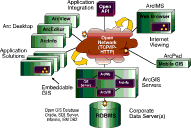
ArcIMS establishes a common platform for the exchange of Web-enabled GIS data and services. More than just an Internet mapping solution, ArcIMS is a framework for distributing GIS capabilities over the Internet. As a publishing technology, ArcIMS features unique capabilities for supporting a wide variety of ESRI clients. As a serving technology, ArcIMS includes a variety of ESRI serverside technologies and provides unique opportunities for data integration.
ArcPad software is an easy-to-use, lightweight, low-cost solution for mobile mapping and geographic information systems (GISs). ArcPad enhances portable touch-screen computers with intuitive mapping, GIS, and GPS functionality. ArcPad makes field data collection fast and easy, improves data accuracy, and provides immediate data availability and validation.
ESRI offers open computing by supporting industry standards. This principle extends to the use of standard open interfaces, file formats, and software and database technology. The solution incorporates open published application program interfaces (eg for ArcSDE access), open published data transfer formats (eg for shapefiles), open industry-standard tools (eg use of OLE/COM and C functions), open platforms, open databases, and open operating systems.
Furthermore, the company's open and scalable GIS solutions can easily integrate into existing enterprise systems and platforms.
GIMS
012 345 8000
Others who read this also read these articles
An intelligent, integrated approach
MapIT has crafted a Licensed Partner programme based on the common requirement for highly accurate mapping data[ October 2004 ]
Picture it ...
MarketScope can calculate virtually any demographic scenario for your marketplace, taking into account a variety of factors, including your customer profiles, census information, competitor analysis data and any other set of business-related statistics you wish to evaluate, and visually display the results, arriving at an answer within 30 seconds[ August 2004 ]
Mondi develops advanced GIS business system
Mondi Forests has a truly integrated GIS business system that not only takes care of daily operational requirements, but also facilitates the use of GIS decision-making technology[ June 2003 ]
Implementation of a GIS system in local government
The most cost effective and user friendly way of implementing the MIS system and making it accessible to all authorised officials and Councillors throughout the Municipality was to build a Web application using Bentley Publisher[ April 2003 ]
GIS technology saluted for social and economic contributions
GIS is a powerful analytical tool that integrates spatial (or location) data with associated information, presenting the result in an easy-to-understand, map-based format[ February 2003 ]
ArcGIS Schematics launched
ArcGIS Schematics offers a high degree of flexibility and is not limited by the evolution of the data model and by changing database locations[ February 2003 ]
Building a locations-based service
Before we can start any project, we need to know and understand what the system is going to be used for[ August 2002 ]
Sustainable fisheries and marine conservation in Kenya
A Microsoft Access database is being developed to manage the data[ August 2002 ]
Others who read this also read these news items
Hikers, bikers and urban street pioneers
[ December 2005 ]
Image compression provides post-Katrina aerials within days
[ December 2005 ]
Navigation - the tip of the GIS iceberg
[ October 2005 ]
Fun and affordable in-car navigation
[ October 2005 ]
Cycling on the edge
[ October 2005 ]
Routing made easy
[ August 2005 ]
MapIT expands into West Africa
[ August 2005 ]
Incredible Connection powers navigation tools
[ August 2005 ]
Others who read this also read these regulars
ArcIMS 9.1 Route Server - routing and geocoding
[ October 2005 ]
Enterprise GIS with ArcGIS 9: a comprehensive GIS platform
[ October 2004 ]
GIS in Africa
[ August 2003 ]
Complete logistics and routing solution
[ August 2002 ]
GIS - the tool to help manage change in the 21st century
[ April/May 2000 ]
GIS software that sets a new standard
[ April/May 2000 ]
Search Site
Subscribe
Previous Issues
Other Technews Publications
Other Technews Buyers Guides
 |  | Copyright c1995-2009 Technews Publishing (Pty) Ltd.. All rights reserved. |