Enterprise GIS with ArcGIS 9: a comprehensive GIS platform
1 October 2004

GIS requirements influence how GIS software is built and used. GIS, similar to other information technology (IT), must be implemented in a manner that easily allows applications to support each organisation's workflows and business requirements. This is accomplished by providing a generic software platform that provides comprehensive support for the complete range of geographic knowledge elements as well as comprehensive tools for data management, editing, analysis and display.
In this context, GIS software can be increasingly thought of as IT infrastructure for assembling large, sophisticated multi-user systems. A GIS platform must provide all the capabilities necessary to support this enlarged vision:
* Geographic database to store and manage all geographic objects.
* A Web-based network for distributed geographic information management and sharing.
* Desktop and server applications for:
* A Web-based network for distributed geographic information management and sharing.
* Desktop and server applications for:
- Data compilation.
- Information query.
- Spatial analysis and geoprocessing.
- Cartographic production.
- Image visualisation and exploitation.
- GIS data management.
* Modular software components (engines) to embed GIS logic in other applications and build custom applications.
* Geographic information services for multitier and centralised GIS systems.
* A comprehensive GIS platform that meets all geographic requirements.
* Geographic information services for multitier and centralised GIS systems.
* A comprehensive GIS platform that meets all geographic requirements.

GIS is inherently distributed
Today, there is widespread recognition that the data layers and tables in most geographic information systems come from multiple organisations. Each GIS organisation develops some, but not all, of its data content. At least some of the layers come from outside the organisation. The necessity for shared GIS data drives users to acquire their data in the most effective and timely manner including acquiring portions of their GIS databases from other GIS users. Thus, GIS data management is distributed among many users.
Interoperability
The distributed nature of GIS has many implications on interoperability between multiple GIS organisations and systems. Collaboration among GIS users is crucial. GIS users have long relied on collaborative efforts for data sharing and use. Recent trends and efforts on GIS standards reflect this fundamental need. Adherence to industry standards and commonly adopted GIS practices is critical to the success of any GIS. A GIS must support critical standards and be able to adapt and evolve as new standards emerge.
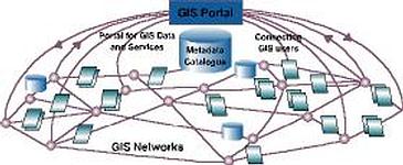
GIS networks
Many geographic data sets can be compiled and managed as a generic information resource and shared among a community of users. In addition, GIS users have envisioned how sharing these commonly used data sets can be accomplished through the Web.
Web nodes, called GIS catalogue portals, can be implemented to allow GIS users to register as well as discover geographic information for access and use. As a consequence, GIS systems are becoming increasingly connected on the World Wide Web for information sharing and use. This vision has been in existence for more than a decade and has been described as a national spatial data infrastructure (NSDI) or a global spatial data infrastructure (GSDI).
These concepts are in general use today, not only at national and global levels but also within states and local communities. This concept is collectively referred to as a Spatial Data Infrastructure (SDI).
Geographic intelligence is inherently distributed and loosely integrated. Rarely is all the necessary information present in a single database instance with a single data schema.
GIS users count on one another for portions of their GIS data.
To cater for all these diverse needs, we need various frameworks for implementing GIS. These include the following:
Desktop GIS
Desktop GIS is the primary seat from which GIS professionals compile, author and use geographic information and knowledge. GIS professionals use a standard desktop as a productivity tool for authoring, sharing, managing and publishing geographic knowledge.
In addition to GIS desktops, GIS software can be centralised in application servers and Web servers to deliver GIS capabilities to any number of users over networks. Focused sets of GIS logic can be embedded and deployed in custom applications. And increasingly, GIS is deployed in mobile devices for field GIS.
Embedded GIS
To provide GIS to the widest possible range of users, it is necessary to embed GIS functionality and data inside other applications. This could be a helper application within a Web browser, functions embedded within word processing documents and spreadsheets, or mapping provided within non-GIS applications (eg, permit tracking, command and control or environmental monitoring systems). These applications require simple, focused user interfaces. However, they access advanced GIS logic to perform a few specific tasks.
Mobile GIS
Mobile computing is creating fundamental changes by adding the ability to take GIS with you into the field and interact directly with the world around you. Mobile GIS is composed of a number of technologies.
* GIS.
* Mobile hardware in the form of lightweight devices and ruggedised field PCs.
* Global positioning systems (GPSs).
* Wireless communications for Internet GIS access.
* Mobile hardware in the form of lightweight devices and ruggedised field PCs.
* Global positioning systems (GPSs).
* Wireless communications for Internet GIS access.
Traditionally, the process of field data collection and editing has been time consuming and error prone. Geographic data has travelled into the field in the form of paper maps. Field edits were performed using sketches and notes on paper maps and clipboards. Once back in the office, these field edits were deciphered and manually entered into the GIS database. The result has been that GIS data has often not been as up-to-date or accurate as it should have been. Consequently, GIS analysis and decisions have been delayed.
Recent developments in mobile technologies have enabled GIS information to be taken into the field as digital maps on compact, powerful mobile computers, providing field access to enterprise geographic information. This enables organisations to add realtime (and near realtime) information to their enterprise database and applications, speeding up analysis, display, and decision making by using up-to-date, more accurate spatial data.
Server-based GIS technology
Server GIS is used for many kinds of centrally hosted GIS computing. The server-based GIS technology trend is growing. GIS software can be centralised in application servers to deliver GIS capabilities to large numbers of users over networks. Enterprise GIS users connect to central GIS servers using traditional desktop GIS as well as Web browsers, mobile computing devices, and digital appliances.
Comprehensive GIS capabilities must be provided to support a broad range of server GIS requirements. For example, server GIS can be used for:
* Managing large GIS databases.
* Internet delivery of geographic information.
* Hosting central GIS Web portals for information discovery and use.
* Centrally hosting GIS functions that are accessed by many users in an organisation.
* Back-office processing of enterprise GIS databases.
* Distributed GIS computing (such as distributed GIS data management and analysis).
* Internet delivery of comprehensive GIS functionality.
The concept of a GIS software seat has proven invaluable and is widely adopted by GIS professionals in nearly 200 000 organisations worldwide. In fact, this client-server computing model has been so successful that many only think of GIS within this context. However, the GIS vision is expanding.
Recent developments in computing-the growth of the Internet, advances in DBMS technology, object-oriented programming, mobile computing, and wide GIS adoption to-have led to an evolving vision and role for GIS.
For more information contact GIMS, 011 695 0400.
Others who read this also read these articles
An intelligent, integrated approach
MapIT has crafted a Licensed Partner programme based on the common requirement for highly accurate mapping data[ October 2004 ]
Picture it ...
MarketScope can calculate virtually any demographic scenario for your marketplace, taking into account a variety of factors, including your customer profiles, census information, competitor analysis data and any other set of business-related statistics you wish to evaluate, and visually display the results, arriving at an answer within 30 seconds[ August 2004 ]
Mondi develops advanced GIS business system
Mondi Forests has a truly integrated GIS business system that not only takes care of daily operational requirements, but also facilitates the use of GIS decision-making technology[ June 2003 ]
Implementation of a GIS system in local government
The most cost effective and user friendly way of implementing the MIS system and making it accessible to all authorised officials and Councillors throughout the Municipality was to build a Web application using Bentley Publisher[ April 2003 ]
GIS technology saluted for social and economic contributions
GIS is a powerful analytical tool that integrates spatial (or location) data with associated information, presenting the result in an easy-to-understand, map-based format[ February 2003 ]
ArcGIS Schematics launched
ArcGIS Schematics offers a high degree of flexibility and is not limited by the evolution of the data model and by changing database locations[ February 2003 ]
Building a locations-based service
Before we can start any project, we need to know and understand what the system is going to be used for[ August 2002 ]
Sustainable fisheries and marine conservation in Kenya
A Microsoft Access database is being developed to manage the data[ August 2002 ]
Others who read this also read these news items
Hikers, bikers and urban street pioneers
[ December 2005 ]
Image compression provides post-Katrina aerials within days
[ December 2005 ]
Navigation - the tip of the GIS iceberg
[ October 2005 ]
Fun and affordable in-car navigation
[ October 2005 ]
Cycling on the edge
[ October 2005 ]
Routing made easy
[ August 2005 ]
MapIT expands into West Africa
[ August 2005 ]
Incredible Connection powers navigation tools
[ August 2005 ]
Others who read this also read these regulars
ArcIMS 9.1 Route Server - routing and geocoding
[ October 2005 ]
GIS in Africa
[ August 2003 ]
Complete logistics and routing solution
[ August 2002 ]
ESRI offers highly integrated GIS solutions
[ April 2002 ]
GIS - the tool to help manage change in the 21st century
[ April/May 2000 ]
GIS software that sets a new standard
[ April/May 2000 ]
Search Site
Subscribe
Previous Issues
Other Technews Publications
Other Technews Buyers Guides
 |  | Copyright c1995-2009 Technews Publishing (Pty) Ltd.. All rights reserved. |