Geographic imaging made easier with new generation software
April 2001
In light of the revolution in the use of geographic imagery (aerial photography, satellite imagery, videography) Erdas, represented locally by GIMS, has complemented its existing Imagine geographic imagining software suite with three new and exciting additions in the field of photogrammetry and visual analysis.
Simple orthorectification of high-resolution imagery using OrthoBASE
Recognising the need for imagery and image-derived spatial data within the geographic information systems environment, Erdas has launched Stereo Analyst version 1.1. The package offers 3D feature extraction from stereo imagery in an easy to use PC-based environment. This alleviates the need for high-end photogrammetric solutions with their associated costs and personnel requirements.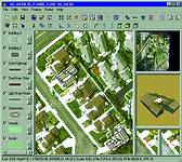
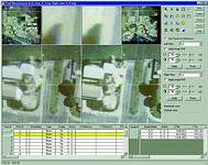
Extracting 3D information with Stereo Analyst’s feature extraction and mensuration tools
"Stereo Analyst is Erdas' practical and affordable solution for 3D feature collection, interpretation and visualisation of stereo imagery," says Lauren Solomon, spokesperson for GIMS. "Now users can transform their 2D GIS into real-world dimensions by collecting 3D geographic information directly from imagery."
Stereo Analyst is a standalone product that easily integrates with Erdas Imagine and ArcView GIS environments. Its potential GIS applications are varied including telecommunications, forestry, state and local government planning and geology.
Stereo Analyst's sophisticated 3D data collection techniques enable users to:
* Accurately collect both 2D and 3D GIS data from a variety of image sources, without having to create a digital terrain model.
* Minimise the time and cost associated with preparing, collecting, and editing GIS data.
* Transform existing 2D GIS vectors into 3D GIS data.
* Automatically attribute spatial information to users' GIS using user-defined data dictionaries implemented through the extensive use of feature tables.
* Immediately use 3D ESRI Shapefiles in Erdas Imagine and ESRI products.
* Verify the accuracy of GIS vector layers and digital stereo models.
"In light of the complexity usually associated with Orthophoto production, Erdas has brought a well designed, user-friendly PC-based solution to the market, which integrates with its existing geographic imaging solutions," continues Solomon. "No previous photogrammetric experience is required, whilst for the experienced photogrammetrist, the tools are designed to accept data inputs from a wider variety of spatial data sources than traditional standalone photogrammetric solutions."
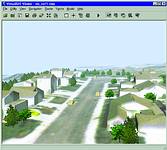
Visualise and analyse your data in 3D with the tools and enhanced features of VirtualGIS
Wizard-based mapping software
Imagine OrthoBASE is Erdas' new Windows-based digital mapping software that simplifies complex photogrammetric procedures. The product's clean design, wizard-based tools and automated processes dramatically reduce the initial learning curve, as well as the time and money spent geocorrecting and orthorectifying images. Imagine OrthoBASE eliminates the current limitations of complex, difficult-to-learn packages while providing rigorous and precise computations and results.
Some of the main capabilities of OrthoBASE are as follows:
* Rigorous sensor modelling of various camera and satellite sensors (SPOT, IRS-1C) as well as generic models for push-broom sensors.
* Supports aerial, oblique and terrestrial (ground-based) imagery.
* Semi-automated interior orientation.
* Automatic tie point collection.
* Ground control point measurement.
* Aerial triangulation.
* Self-calibrating bundle adjustment allows for the use of 35 mm, digital cameras, video cameras and archival photography.
* Sophisticated automatic error checking models.
* Block adjustment of sensor models resulting in a better fit between adjacent images and better overall accuracy with less control points.
* Orthorectification of images within a block based on an existing digital elevation model.
In the provision of a complete solution, OrthoBASE can supply stereo pair data for use in Stereo Analyst in the extraction of elevation information (buildings heights, contours values, etc). The elevation information collected can then be used in the generation of a digital elevation model, which when loaded into OrthoBASE can be used to generate a digital orthophoto.
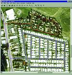
Using high-resolution imagery to update your database of residential zones
3D analysis tool assists decision-making
In the field of geographic imaging, the ability to visualise spatial data within a three-dimensional environment, adds significant value to the decision making process. Erdas has developed a 3D environment that is integrated within the Imagine geographic imaging suite and adds comprehensive visualisation functionality to the already rich imaging toolset.
Imagine VirtualGIS is a powerful, three-dimensional visual analysis tool that offers GIS functions and capabilities in a 3D environment.
"It takes users' projects to a new level through interactive 3D modelling, intervisibility/threat analysis, VRML 2.0 support for creating 3D web content, realtime anaglyph stereo (no need for specialised graphics cards) and the generation of high-resolution 3D images for printing," says Solomon.
The functionality of Imagine VirtualGIS enables users to:
* Extend the Geographic Imaging functions of Erdas Imagine, within a realtime, 3D environment.
* Experience realtime, 3D navigation through a large database of image, map and attribute data.
* Geographically link 3D and 2D views of the same location.
* Apply enhancement functions and spatial filters within the 3D environment.
* Query attributes of image and vector data interactively in 3D.
* Fly through a database using predefined flight paths or using mouse controls.
* Output to standard movie formats and VRML.
* Calculate visible and obscured locations for a particular viewing location.
"This functionality is essential in many environmental, telecommunication, and defence applications," Solomon concludes.
Geographic Information Management Systems (GIMS)
(011) 315 0390
Footnote: All imagery provided courtesy of Golden State Aerial Surveys and City of San Louis Obispo, CA.
Others who read this also read these articles
An intelligent, integrated approach
MapIT has crafted a Licensed Partner programme based on the common requirement for highly accurate mapping data[ October 2004 ]
Picture it ...
MarketScope can calculate virtually any demographic scenario for your marketplace, taking into account a variety of factors, including your customer profiles, census information, competitor analysis data and any other set of business-related statistics you wish to evaluate, and visually display the results, arriving at an answer within 30 seconds[ August 2004 ]
Mondi develops advanced GIS business system
Mondi Forests has a truly integrated GIS business system that not only takes care of daily operational requirements, but also facilitates the use of GIS decision-making technology[ June 2003 ]
Implementation of a GIS system in local government
The most cost effective and user friendly way of implementing the MIS system and making it accessible to all authorised officials and Councillors throughout the Municipality was to build a Web application using Bentley Publisher[ April 2003 ]
GIS technology saluted for social and economic contributions
GIS is a powerful analytical tool that integrates spatial (or location) data with associated information, presenting the result in an easy-to-understand, map-based format[ February 2003 ]
ArcGIS Schematics launched
ArcGIS Schematics offers a high degree of flexibility and is not limited by the evolution of the data model and by changing database locations[ February 2003 ]
Building a locations-based service
Before we can start any project, we need to know and understand what the system is going to be used for[ August 2002 ]
Sustainable fisheries and marine conservation in Kenya
A Microsoft Access database is being developed to manage the data[ August 2002 ]
Others who read this also read these news items
Hikers, bikers and urban street pioneers
[ December 2005 ]
Image compression provides post-Katrina aerials within days
[ December 2005 ]
Navigation - the tip of the GIS iceberg
[ October 2005 ]
Fun and affordable in-car navigation
[ October 2005 ]
Cycling on the edge
[ October 2005 ]
Routing made easy
[ August 2005 ]
MapIT expands into West Africa
[ August 2005 ]
Incredible Connection powers navigation tools
[ August 2005 ]
Others who read this also read these regulars
ArcIMS 9.1 Route Server - routing and geocoding
[ October 2005 ]
Enterprise GIS with ArcGIS 9: a comprehensive GIS platform
[ October 2004 ]
GIS in Africa
[ August 2003 ]
Complete logistics and routing solution
[ August 2002 ]
ESRI offers highly integrated GIS solutions
[ April 2002 ]
GIS - the tool to help manage change in the 21st century
[ April/May 2000 ]
GIS software that sets a new standard
[ April/May 2000 ]
Search Site
Subscribe
Previous Issues
Other Technews Publications
Other Technews Buyers Guides
 |  | Copyright c1995-2009 Technews Publishing (Pty) Ltd.. All rights reserved. |