Mobile mapping on-demand - active representation and automated generalisation of special databases for the wireless handheld information appliance - Part II
April 2001
P.G. Hardy, Laser-Scan, UK
Part I introduced the way that the Internet has become the major information repository for mankind, and went into the various handheld appliances available for gaining access to this information while on the move. For map information to be of value to the reader, use of active objects provides the map generation process with the ability to display only pertinent information in a clear manner on a screen that may have limited resolution. Part II continues – looking at the part generalisation plays in the map representation process.
4. Generalisation
4.1 Active object generalisation
Generalisation is the science (and art) of exaggerating those aspects that are important for this particular map purpose and scale and removing irrelevant detail that would clutter the map and confuse the user. Generalisation has traditionally been a hard task to automate, being dependent on the skills of the human cartographer. People have tried for years to build centralised 'knowledge bases' of generalisation rules, with very limited success. In such systems, the map features themselves have just been passive items containing coordinates and attributes, acted upon by the centralised rules [McMaster, 1991].
In the object-oriented world, this is turned upside down. The map features themselves become objects that have generalisation behaviours defined in the database schema. The application itself becomes much thinner and contains no knowledge about what, how or when. It merely provides a framework for invoking and sequencing the generalisation processes by sending messages to selected objects [Ormsby and Mackaness, 1999].
Gothic LAMPS2 includes an object-oriented generalisation facility which allows the user to define the strategy for generalisation in terms of methods on the object classes [Hardy 2000]. Generalisation base object classes are provided which supply generalisation process methods for multi-object combinatorial operations (aggregation, typification and displacement) and others for single object generalisation (collapsing, refinement, exaggeration and simplification). Note that these are implemented as behaviours of the objects in the database, not as commands within a program.
Kort & Matrikelstyrelson (the Danish state mapping agency) is using LAMPS2 in this way to derive 1:50K mapping from a 1:10K sourced database. The generalisation flowline makes considerable use of active object views using spatial query, to identify objects for generalisation. An example is to delete all minor roads less than 2 km long, which have a dead end and do not have buildings within 100 m of the dead end.
In the future, increased computational power and improvements in software techniques will allow such active object generalisation to be done in realtime, on-demand to satisfy a user request for appropriate mapping on his WHIA. Until then, the techniques are still very useful, but need to be applied in advance to produce a set of 'usages' and the results stored. The object database allows storage of multiple alternative geometries, so you can have one object (eg Trinity College), with one set of attributes, but with several alternative sets of coordinates, each suitable for a particular scale band.
4.2 Agent generalisation
The power of object generalisation is being greatly enhanced by the Agent project on multi-agent generalisation. This project [Lamy et al, 1999] is a collaboration under the Esprit programme (LTR/24939) involving Laser-Scan as providers of object technology together with a national mapping agency (IGN) as prime contractor and academic partners (Edinburgh & Zurich, INPG). Some partners provide in-depth knowledge of generalisation algorithms, while others provide insight into multi-agent modelling. The contract involves 48 person years of effort over a three-year period. The fruits of the project are being implemented in the Laser-Scan Gothic LAMPS2 mapping software.
In this context, agents are self-aware active software objects that cooperate, subject to a set of constraints, to achieve a goal. For map generalisation, it is the geographic objects such as houses and roads which become active agents and cooperate through simplification, typification and displacement of themselves to achieve a cartographically acceptable generalised result.
Agent-based generalisation achieves two major steps forward:
* An individual micro-agent (eg a building) tries different algorithms, keeping the results if the situation is better, discarding and trying different ones if the situation is worse, so avoiding using the same tool globally.
* Meso agents coordinate generalisation across sets of objects, so avoid consequential conflicts and retain gestalt (the overall coherence).
* Meso agents coordinate generalisation across sets of objects, so avoid consequential conflicts and retain gestalt (the overall coherence).
Like the active object generalisation techniques described in the previous section, these agent techniques at present are to be used in preparing generalised versions of objects to be used for different scale enquiries. In the future, they will be applied in realtime to satisfy mapping requests from WHIAs.
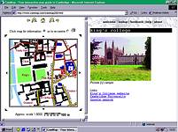
Figure 1. Web mapping - www.CamMap.com
5. Web mapping examples
5.1 CamMap
CamMap is a highly interactive web map of the area around Cambridge, UK. In it, all the objects can be asked to describe themselves, and many (including all pubs, colleges and many public buildings) do so by providing web links to images and related websites (eg for Kings College as shown in Figure 1). The site is free, so try it out yourself ( http://www.CamMap.com) It uses a variety of active object generalisation techniques to present data from a continuous object database at different scales while retaining clarity.
Figure 2 shows intelligent generalisation and positioning of text labels. Road numbers have been dropped where there is insufficient room. Road and pub names have been positioned so that they do not fall over the edge of the window or over important detail. Figure 2 shows automatic selection of appropriately pre-generalised geometry for a college according to viewing scale. The combination of these techniques produces a legible map presenting the maximum information, for any requested location at any requested scale, within seconds.
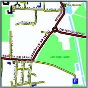
Figure 2. Text labelling
5.2 Location mapping
A commercial website is being implemented to provide location mapping. It has national coverage sourced and derived from Ordnance Survey digital map data. It allows look-up of an address by text or by postcode, and can provide a sequence of four location maps at increasing scales in a patented layout leading the user to the desired location. As well as the on-screen version, the user can request a print-quality map which is delivered in Adobe Acrobat PDF format, for printing at A4. Both map types are produced using active object representation and generalisation from a continuous object database.
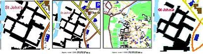
Figure 3. Use of generalised geometry for college building outline according to viewing scale
5.3 LINZ
Land Information New Zealand already hold the master data for their 1:50K national topographic database in a single continuous Gothic dataset administered with LAMPS2, supporting on-demand hardcopy mapping. More recently, they have asked Laser-Scan to serve a copy of the data from Cambridge, UK, to the Internet for use by NZ government departments. The web application uses a Java applet for better interaction than can be achieved with just HTML. Hardcopy output is still available via download of a generated PostScript file covering the area of interest. Display methods on the objects in the database choose if and how to draw themselves, to provide a clear map at a variety of scales. NZ has recently chosen to makes its topographic data freely available (as in the US) rather than charging copyright fees. Topograhpic mapping of this type will become a valuable framework and backdrop for handheld spatial information retrieval on WHIAs in the future, for those countries that have the foresight to release their mapping in this way.
5.4 EDINA Digimap
EDINA Digimap, which is hosted at Edinburgh University Data Library (EUDL), provides on-line access to OS digital mapping for the UK Higher Education Community (Universities and Colleges). The current system is a limited prototype and EDINA are currently re-engineering Digmap to user Laser-Scan Gothic software for deployment early in 2001. The active object dataset underlying the new Digimap will be one of the largest continuous map databases in the world and will be an excellent testbed for future access to such information from WHIAs. The continuous object dataset and active object representation are key to providing good cartographic quality for demands for arbitrary sized areas of mapping at different scales.
6. Interoperability
6.1 OGC web mapping
The OpenGIS Consortium ( http://www.opengis.org/</a>) brings together software suppliers, spatial data suppliers and major government agencies to define protocols and interfaces for interoperability. In particular, it has defined three APIs (GetCapabilities, GetMap and GetFeatureInfo), that together allow spatial data from multiple sources to be displayed together in a web browser. These APIs evolved in Web Mapping Testbed 1 (WMT1) and subsequently refined and adopted as the OpenGis Web Map Server Interface Implementation Specification.
In WMT1, transportation data from a Laser-Scan Gothic object database was combined with satellite imagery, terrain models, flood predictions and emergency capabilities, in a simulation of a hurricane landfall over Mobile, Alabama. Once again, the active object selection and representation of Gothic allowed clear display. In the future, WHIAs will be a central way of disseminating such emergency information and presenting it to the user in a clear manner.
7. Mobile mapping
7.1 WAP maps
The small screen of current WAP phones limits their use for presenting location information graphically, but with intelligent object selection and representation as described in earlier sections of this paper, useful results can be shown. CamWAP ( http://wap.CamMap.com), an alternative view of the CamMap web mapping site uses the same active object dataset, but different display methods, to enhance clarity on the low-resolution monochrome screen. An example is the use of automatic text haloing to erase background and clear space for the important text labels. The CamWap implementation builds on research collaboration between Laser-Scan and the Department of Geography at Edinburgh University.
7.2 Future mobile maps
The limitations of WAP and current mobile phone screens will not hold us back for long. The future WHIA will have a screen at least as capable as a modern palmtop and hence the development of mobile mapping must concentrate on clear presentation on screens of about a megapixel.
8. Conclusion
The rise of the Internet has already changed the way that many users access spatial information. No longer is the printed map the primary medium. The union of the mobile phone with the PDA and other new technology will produce the WHIA, a wireless handheld information appliance. WHIAs will become over the next few years the central medium for information retrieval, particularly location-related information in the form of active maps.
This shift from paper hardcopy to mobile screen softcopy will greatly affect the nature of the cartographic business. Major parts of the knowledge and skill of human cartographers will need to be embedded in realtime generalisation software (using active representation and intelligent spatial feature generalisation) and in pre-prepared generalised 'usages' within digital databases.
Active object technology in the information server is crucial to on-demand retrieval and clear presentation of the requisite information in the form of an active map on the WHIA, tailored to the user's current need.
The technology discussed in this article is available through Racal Aviation Systems, (021) 936 8100, gis@resa.co.za
Others who read this also read these articles
An intelligent, integrated approach
MapIT has crafted a Licensed Partner programme based on the common requirement for highly accurate mapping data[ October 2004 ]
Picture it ...
MarketScope can calculate virtually any demographic scenario for your marketplace, taking into account a variety of factors, including your customer profiles, census information, competitor analysis data and any other set of business-related statistics you wish to evaluate, and visually display the results, arriving at an answer within 30 seconds[ August 2004 ]
Mondi develops advanced GIS business system
Mondi Forests has a truly integrated GIS business system that not only takes care of daily operational requirements, but also facilitates the use of GIS decision-making technology[ June 2003 ]
Implementation of a GIS system in local government
The most cost effective and user friendly way of implementing the MIS system and making it accessible to all authorised officials and Councillors throughout the Municipality was to build a Web application using Bentley Publisher[ April 2003 ]
GIS technology saluted for social and economic contributions
GIS is a powerful analytical tool that integrates spatial (or location) data with associated information, presenting the result in an easy-to-understand, map-based format[ February 2003 ]
ArcGIS Schematics launched
ArcGIS Schematics offers a high degree of flexibility and is not limited by the evolution of the data model and by changing database locations[ February 2003 ]
Building a locations-based service
Before we can start any project, we need to know and understand what the system is going to be used for[ August 2002 ]
Sustainable fisheries and marine conservation in Kenya
A Microsoft Access database is being developed to manage the data[ August 2002 ]
Others who read this also read these news items
Hikers, bikers and urban street pioneers
[ December 2005 ]
Image compression provides post-Katrina aerials within days
[ December 2005 ]
Navigation - the tip of the GIS iceberg
[ October 2005 ]
Fun and affordable in-car navigation
[ October 2005 ]
Cycling on the edge
[ October 2005 ]
Routing made easy
[ August 2005 ]
MapIT expands into West Africa
[ August 2005 ]
Incredible Connection powers navigation tools
[ August 2005 ]
Others who read this also read these regulars
ArcIMS 9.1 Route Server - routing and geocoding
[ October 2005 ]
Enterprise GIS with ArcGIS 9: a comprehensive GIS platform
[ October 2004 ]
GIS in Africa
[ August 2003 ]
Complete logistics and routing solution
[ August 2002 ]
ESRI offers highly integrated GIS solutions
[ April 2002 ]
GIS - the tool to help manage change in the 21st century
[ April/May 2000 ]
GIS software that sets a new standard
[ April/May 2000 ]
Search Site
Subscribe
Previous Issues
Other Technews Publications
Other Technews Buyers Guides
 |  | Copyright c1995-2009 Technews Publishing (Pty) Ltd.. All rights reserved. |