GIS: the way forward in the Peace Parks Foundation
April 2001
Dr Anton Rupert (Chairman)

“Peace Parks offer a vision for the future of Africa which is practical, realistic and attainable. People will benefit, and wildlife sanctuaries will be joined together in a continuum, bequeathing future generations a priceless asset. The promotion of an associated culture of peace should be welcomed by all. It is long overdue.”
The Peace Parks Foundation (PPF) is a non-profit organisation with a mission to facilitate the establishment of Transfrontier Conservation Areas (TFCAs) in the Southern African Development Community (SADC) supporting sustainable economic development, the conservation of biodiversity, and regional peace and stability. The foundation is managed by a Board of Directors under the Chairmanship of Dr Anton Rupert; and the Executive Directorship of Prof Willem van Riet, and has seven Honorary Patrons, Nelson Mandela being the Patron Emeritus.
The vision of the PPF is to develop a network of Transfrontier Conservation Areas by unifying fragmented ecological habitats and promoting environmental and political stability in Africa. In order to do this one needs a unique level of international cooperation between the participating countries, particularly on sensitive issues, such as the opening of international boundaries, and cross border management of the parks, thus deeming support from top political levels necessary.
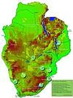
Just as importantly one needs an effective GIS (geographic information systems) to moderate the planning and facilitate the monitoring of each TFCA with its own specific requirements. As a result the Peace Parks Foundation has established an internal GIS laboratory. It is felt that the development and management of Transfrontier Conservation Areas (TFCAs) without the use of this technology cannot be possible. The TFCA projects (see map 1) which are currently underway are:
* The Kgalagdi Transfrontier Park (which opened on 12 May 2000).
* Gaza/Kruger/Gonarezhou TFCA (the international agreement of development was signed on 10 November 2000).
* Richtersveld/Ai-Ais TFCA; Gariep TFCA; Limpopo/Shashe TFCA; Lubombo TFCA; Outzit TFCA; Maloti/Drakensberg TFCA.
* The Nyassa/Niasa TFCA.
* Gaza/Kruger/Gonarezhou TFCA (the international agreement of development was signed on 10 November 2000).
* Richtersveld/Ai-Ais TFCA; Gariep TFCA; Limpopo/Shashe TFCA; Lubombo TFCA; Outzit TFCA; Maloti/Drakensberg TFCA.
* The Nyassa/Niasa TFCA.
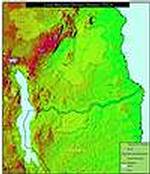
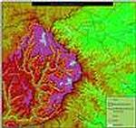
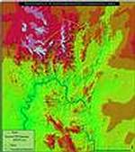
In planning and monitoring of any TFCA it is essential to have up-to-date information of land use, settlement patterns, vegetation, soils, geology infrastructure and population density to name but a few. Satellite imagery is used to effectively derive some of the data, which is required during the planning of each TFCA. In Africa the GIS data resources are updated infrequently and therefore the accuracy, availability and metadata associated with the data are questionable. As a result the most feasible method of attaining data of the quality required is through satellite imagery, heads-up digitising and field surveys.
"Peace Parks Foundation wishes to thank ESRI and GIMS for their inclusion into their Conservation Programme," says Craig Beech of the Foundation. "This programme kindly donated ArcView GIS with extensions 3D Analyst, Spatial Analyst and Tracking Analyst, as well as MapObjects. This software is crucial to the analysis and planning of the TFCAs and has already been used to capture and analyse data from Coutada 16 in Mozambique. MapObjects Lt is being used to develop a customised piece of software to allow for the dissemination of spatial data to key role players," he concludes.
Peace Parks Foundation GIS
(021) 887 6188
Geographic Information Management Systems (GIMS)
(011) 315 0390
Others who read this also read these articles
An intelligent, integrated approach
MapIT has crafted a Licensed Partner programme based on the common requirement for highly accurate mapping data[ October 2004 ]
Picture it ...
MarketScope can calculate virtually any demographic scenario for your marketplace, taking into account a variety of factors, including your customer profiles, census information, competitor analysis data and any other set of business-related statistics you wish to evaluate, and visually display the results, arriving at an answer within 30 seconds[ August 2004 ]
Mondi develops advanced GIS business system
Mondi Forests has a truly integrated GIS business system that not only takes care of daily operational requirements, but also facilitates the use of GIS decision-making technology[ June 2003 ]
Implementation of a GIS system in local government
The most cost effective and user friendly way of implementing the MIS system and making it accessible to all authorised officials and Councillors throughout the Municipality was to build a Web application using Bentley Publisher[ April 2003 ]
GIS technology saluted for social and economic contributions
GIS is a powerful analytical tool that integrates spatial (or location) data with associated information, presenting the result in an easy-to-understand, map-based format[ February 2003 ]
ArcGIS Schematics launched
ArcGIS Schematics offers a high degree of flexibility and is not limited by the evolution of the data model and by changing database locations[ February 2003 ]
Building a locations-based service
Before we can start any project, we need to know and understand what the system is going to be used for[ August 2002 ]
Sustainable fisheries and marine conservation in Kenya
A Microsoft Access database is being developed to manage the data[ August 2002 ]
Others who read this also read these news items
Hikers, bikers and urban street pioneers
[ December 2005 ]
Image compression provides post-Katrina aerials within days
[ December 2005 ]
Navigation - the tip of the GIS iceberg
[ October 2005 ]
Fun and affordable in-car navigation
[ October 2005 ]
Cycling on the edge
[ October 2005 ]
Routing made easy
[ August 2005 ]
MapIT expands into West Africa
[ August 2005 ]
Incredible Connection powers navigation tools
[ August 2005 ]
Others who read this also read these regulars
ArcIMS 9.1 Route Server - routing and geocoding
[ October 2005 ]
Enterprise GIS with ArcGIS 9: a comprehensive GIS platform
[ October 2004 ]
GIS in Africa
[ August 2003 ]
Complete logistics and routing solution
[ August 2002 ]
ESRI offers highly integrated GIS solutions
[ April 2002 ]
GIS - the tool to help manage change in the 21st century
[ April/May 2000 ]
GIS software that sets a new standard
[ April/May 2000 ]
Search Site
Subscribe
Previous Issues
Other Technews Publications
Other Technews Buyers Guides
 |  | Copyright c1995-2009 Technews Publishing (Pty) Ltd.. All rights reserved. |