GIS applications in marine and coastal management in South Africa
November 2001
In the past, Geographic Information Systems in the marine environment has been used by oceanographers and geographers. Recent factors which have increased the exposure of marine geography, and ultimately marine GIS, include the rising global environmental awareness and concerns, increased pollution and the threat to marine fish populations.
A significant proportion of fishery marine areas are in a crisis, the results of which are manifest in the spatio-temporal domain. Thus decisions on their management and remediation can best be made using tools that are efficient at functioning in the spatio-temporal domain. The use of GIS in marine and coastal management in South Africa is a relatively new approach and has been applied to fisheries, intertidal zones and coastal remote sensing.
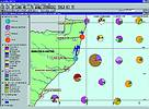
Percentage composition of fish larvae in different estuarine systems along the coast of KwaZulu-Natal
Fisheries applications
GIS analysis of larval fish composition and abundance on the north-east coast of South Africa demonstrated how the composition and abundance of larval fish assemblages changes with different marine habitats along the coast. The two coral reef sites in the north, Kosi and Sodwana, have many different families of fish larvae present. In contrast, the estuaries are dominated by a few families in large numbers. There are less species with an Indo-Pacific distribution range and more that are endemic, the further south you go down the coast of South Africa.
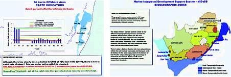
Some sample web pages being developed for MIDeSS
Coastal Decision GIS
During the last five years, the KwaZulu-Natal Wildlife has been developing a Coastal Decision GIS with detailed information on the intertidal zone, from the top of the dunes down to the spring low tide mark. From these data (100 m blocks), KZN Wildlife are able to determine, for example, mussel density and zooanthid abundance every 100 m on the KZN coast.
An integral part of the South African Integrated Spatial Information System (SA-ISIS, funded by the Department of Art, Culture, Science and Technology) is the Marine Integrated Development Support System (MIDeSS). MIDeSS is a decision support system using GIS for sustainable development and management of the South African coastline and is under development by the Marine Indicator Group of SA-ISIS. This information will be available on the Internet for decision-makers from national to local level.
Another project currently underway is the Determination of Marine Reserves by applying C-Plan (Conservation Planning Software with a GIS Interface, NSW National Parks and Wildlife Services, Australia). Critical biota for all marine ecosystems, habitats and biotopes in South Africa will be identified and incorporated into GIS coverages.
The SA Coastal Information Centre (Department of Environmental Affairs and Tourism, DEAT) has an interactive GIS coastal mapping website - a 'virtual spatial library' ( sacoast.uwc.ac.za) which is part of the coastal management awareness campaign.
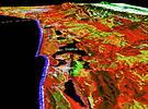
The above image and a 3D model were created by draping a SPOT 4 satellite image over a digital elevation model (DEM). ERDAS Imagine Virtual GIS software was used for this process. The DEM was created from digital 20 m topographic contour data (supplied by the Chief Directorate of Surveys and Mapping, South Africa)
Coastal remote sensing
The CSIR has developed the Oteniqua Coastal Decision Support System (which was implemented in 1995 as a joint project between DEAT and CSIR). The project uses satellite imagery and GIS to map-sensitive coastal areas using vegetation and land use information. All software was supplied by GIMS.
GIMS
(011) 315 0390
Others who read this also read these articles
An intelligent, integrated approach
MapIT has crafted a Licensed Partner programme based on the common requirement for highly accurate mapping data[ October 2004 ]
Picture it ...
MarketScope can calculate virtually any demographic scenario for your marketplace, taking into account a variety of factors, including your customer profiles, census information, competitor analysis data and any other set of business-related statistics you wish to evaluate, and visually display the results, arriving at an answer within 30 seconds[ August 2004 ]
Mondi develops advanced GIS business system
Mondi Forests has a truly integrated GIS business system that not only takes care of daily operational requirements, but also facilitates the use of GIS decision-making technology[ June 2003 ]
Implementation of a GIS system in local government
The most cost effective and user friendly way of implementing the MIS system and making it accessible to all authorised officials and Councillors throughout the Municipality was to build a Web application using Bentley Publisher[ April 2003 ]
GIS technology saluted for social and economic contributions
GIS is a powerful analytical tool that integrates spatial (or location) data with associated information, presenting the result in an easy-to-understand, map-based format[ February 2003 ]
ArcGIS Schematics launched
ArcGIS Schematics offers a high degree of flexibility and is not limited by the evolution of the data model and by changing database locations[ February 2003 ]
Building a locations-based service
Before we can start any project, we need to know and understand what the system is going to be used for[ August 2002 ]
Sustainable fisheries and marine conservation in Kenya
A Microsoft Access database is being developed to manage the data[ August 2002 ]
Others who read this also read these news items
Hikers, bikers and urban street pioneers
[ December 2005 ]
Image compression provides post-Katrina aerials within days
[ December 2005 ]
Navigation - the tip of the GIS iceberg
[ October 2005 ]
Fun and affordable in-car navigation
[ October 2005 ]
Cycling on the edge
[ October 2005 ]
Routing made easy
[ August 2005 ]
MapIT expands into West Africa
[ August 2005 ]
Incredible Connection powers navigation tools
[ August 2005 ]
Others who read this also read these regulars
ArcIMS 9.1 Route Server - routing and geocoding
[ October 2005 ]
Enterprise GIS with ArcGIS 9: a comprehensive GIS platform
[ October 2004 ]
GIS in Africa
[ August 2003 ]
Complete logistics and routing solution
[ August 2002 ]
ESRI offers highly integrated GIS solutions
[ April 2002 ]
GIS - the tool to help manage change in the 21st century
[ April/May 2000 ]
GIS software that sets a new standard
[ April/May 2000 ]
Search Site
Subscribe
Previous Issues
Other Technews Publications
Other Technews Buyers Guides
 |  | Copyright c1995-2009 Technews Publishing (Pty) Ltd.. All rights reserved. |