Web-based solution provides farmers with more accurate farm management possibilities
December 2001
Growing economic pressures, a decrease in the availability of arable land, adverse climatic conditions and volatile commodity markets compel today's farmer to minimise risk, optimise inputs and cut production costs.
Growing economic pressures, a decrease in the availability of arable land, adverse climatic conditions and volatile commodity markets compel today's farmer to minimise risk, optimise inputs and cut production costs.
This is the view of Pieter Schoeman, Account Manager: Agricultural and Environmental GIS at Open Spatial Solutions. He adds that traditional farming methods do not provide adequate solutions nowadays to achieve financial success or sustainability in the agricultural arena.
As part of the M Squared Investments group, Open Spatial partners with its clients in an in-depth business analysis to help the organisation to solve specific business problems with a customised spatial solution based on a Geographic Information System (GIS).
Schoeman says Open Spatial used GIS technology to develop MyPlaas.co.za - a web-based farming solution that enables the farmer to manage his farming activities more effectively with the resources at his disposal. "The solution encompasses the major expenses the farmer must manage per land area or 'management zone' in order to facilitate lower input costs and higher yield - and therefore profits - by applying accurate farm management techniques."
Informed decisions
Schoeman says in the farming arena, what does not get measured does not get managed. "It is no wonder then, that less than 10% of South African farmers know the exact land area of their tillable fields, whilst only a small number are, for example, able to calculate accurately their fuel consumption per cultivated section."
"Also, for most farmers using traditional methods it is almost impossible to work out the difference in income per hectare for different land areas, let alone interpret such variations."
Schoeman says that MyPlaas.co.za is a tool that enables the farmer to make informed decisions on a daily basis about input and production costs, as well as what crops must be planted and when, based on comprehensive and accurate information.
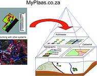
Three building blocks contain the information in MyPlaas.co.za - a spatial layer, an alphanumeric layer and a layer consisting of satellite-based agricultural data.
On the spatial level, all elements in the geographical layer such as roads, irrigation lines, land types and soil types are described via accurate Global Positioning System (GPS) surveying.
Schoeman says it is of the utmost importance that these land areas are precisely measured, since the farmer has to calculate his input costs accordingly. "From this and additional collated geographic information, Open Spatial Solutions builds colour-coded maps with realtime capabilities."
On the alphanumerical level, Open Spatial works with an agricultural economist, using scenario analyses to determine costs for all farming activities, Schoeman explains. "The system utilises crop information such as the planting date and crop type, cultivation information such as implements used, as well as general buying information like fuel, fertiliser and seed purchase to determine cost per hectare."
Schoeman says Open Spatial integrates the financial and agricultural information into a database from which the farmer can analyse and interpret all production activities.
In cooperation with AgriMage in the CSIR group, MyPlaas.co.za will also provide a third layer, satellite-based product specifically developed to supply affordable and user-friendly agricultural spatial information to the individual farmer at regular intervals.
Schoeman says the major difference between MyPlaas.co.za and similar farm management systems is the fact that the farmer receives, and is able to interpret, powerful information on a daily basis without having to navigate a complicated process of questions and answers.
"MyPlaas.co.za also enables the farmer to make comparisons from year to year and between cultivated areas as soon as a historical database of information has been established, facilitating better planning for the future."
In addition, MyPlaas.co.za provides accurate farm maps and management information required by cooperatives, banks and insurance companies, when the farmer applies for financial support.
Schoeman says the farmer does not have to buy any software since Open Spatial hosts MyPlaas.co.za on a central server and the farmer accesses his individual information via the Internet with a secure username and password.
"Additionally, MyPlaas.co.za only requires Internet Explorer and the farmer then pays a set fee per year according to the farming area that he wishes to manage." Schoeman says the price is largely dependent on the size of the farm with a minimum cost of R2000 per year.
The solution is user-friendly, Schoeman says, adding that Open Spatial's support desk provides an after-hours service to solve post-implementation problems and answer possible queries.
Moreover, back-ups of each subscriber's data are also stored on Open Spatial's central server, providing the farmer with peace of mind that his farm management information is secure.
"MyPlaas.co.za has been developed in South Africa for the individual needs of the South African farmer and will eventually be available in Afrikaans, English and Zulu," Schoeman concludes.
Open Spatial Solutions
(011) 324 3800
Others who read this also read these articles
An intelligent, integrated approach
MapIT has crafted a Licensed Partner programme based on the common requirement for highly accurate mapping data[ October 2004 ]
Picture it ...
MarketScope can calculate virtually any demographic scenario for your marketplace, taking into account a variety of factors, including your customer profiles, census information, competitor analysis data and any other set of business-related statistics you wish to evaluate, and visually display the results, arriving at an answer within 30 seconds[ August 2004 ]
Mondi develops advanced GIS business system
Mondi Forests has a truly integrated GIS business system that not only takes care of daily operational requirements, but also facilitates the use of GIS decision-making technology[ June 2003 ]
Implementation of a GIS system in local government
The most cost effective and user friendly way of implementing the MIS system and making it accessible to all authorised officials and Councillors throughout the Municipality was to build a Web application using Bentley Publisher[ April 2003 ]
GIS technology saluted for social and economic contributions
GIS is a powerful analytical tool that integrates spatial (or location) data with associated information, presenting the result in an easy-to-understand, map-based format[ February 2003 ]
ArcGIS Schematics launched
ArcGIS Schematics offers a high degree of flexibility and is not limited by the evolution of the data model and by changing database locations[ February 2003 ]
Building a locations-based service
Before we can start any project, we need to know and understand what the system is going to be used for[ August 2002 ]
Sustainable fisheries and marine conservation in Kenya
A Microsoft Access database is being developed to manage the data[ August 2002 ]
Others who read this also read these news items
Hikers, bikers and urban street pioneers
[ December 2005 ]
Image compression provides post-Katrina aerials within days
[ December 2005 ]
Navigation - the tip of the GIS iceberg
[ October 2005 ]
Fun and affordable in-car navigation
[ October 2005 ]
Cycling on the edge
[ October 2005 ]
Routing made easy
[ August 2005 ]
MapIT expands into West Africa
[ August 2005 ]
Incredible Connection powers navigation tools
[ August 2005 ]
Others who read this also read these regulars
ArcIMS 9.1 Route Server - routing and geocoding
[ October 2005 ]
Enterprise GIS with ArcGIS 9: a comprehensive GIS platform
[ October 2004 ]
GIS in Africa
[ August 2003 ]
Complete logistics and routing solution
[ August 2002 ]
ESRI offers highly integrated GIS solutions
[ April 2002 ]
GIS - the tool to help manage change in the 21st century
[ April/May 2000 ]
GIS software that sets a new standard
[ April/May 2000 ]
Search Site
Subscribe
Previous Issues
Other Technews Publications
Other Technews Buyers Guides
 |  | Copyright c1995-2009 Technews Publishing (Pty) Ltd.. All rights reserved. |