Namdeb Mineral Resource Department chooses GeoMedia Professional and GeoMedia Webmap
December 2001
Namdeb's operations extend from the banks of the Orange River in the south, along the coast to beyond Luderitz in the north. Mining activities also include the inshore coastal strip as well as a large marine mining licence.
Namdeb's operations extend from the banks of the Orange River in the south, along the coast to beyond Luderitz in the North. Mining activities also include the inshore coastal strip as well as a large marine mining licence.
The data held at Namdeb is of such a diverse nature, and covers such a large area that it would not be possible to collate the information using traditional paper/overlay methods. In response to this situation, Intergraph's GeoMedia Geographical Information System (GIS) was acquired to allow for the visualisation of these extensive spatial datasets. The GIS is now able to assist in all aspects of mineral resource management.
One of the greatest challenges managing such a large volume of geospatial information is the integration of data from a variety of sources in an even greater variety of coordinate systems and projections. In addition the data exists in a variety of formats, including Microstation, Access, ArcView/ArcInfo, SQL, and many others. These problems have been overcome using GeoMedia Professional and it is now possible to view historic information in conjunction with more recently acquired data.
On a mine that extends over such great distances the speedy delivery of information is of great importance. The mineral resource offices are up to 250 km apart and accurate, updated information is required at all locations. Namdeb is the first mining company in southern Africa to use Intergraph's GeoMedia Webmap. This system of publishing allows complex GIS maps to be available throughout the mine through Internet explorer.

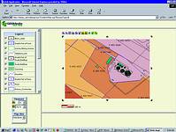
Vessel tracking
Example 1: Marine Production
The Namdeb Mineral Resource Department has integrated a DGPS vessel tracking system with GIS data. It is now possible to monitor the realtime positions of marine production vessels against a backdrop of geological interpretations, high-resolution geophysics or resource estimations. Using GeoMedia Webmap this information is then available to the people who need it, as they need it.
Mine plan
Example 2: Mine planning, production and depletion
A web-based version of the mine plan is available on the intranet to assist in mine planning, production and resource reconciliation. The mine plan is linked directly to the resource database where production and depletion entries are stored. This means that the resource inventory may be queried from any production centre, as the information is needed.
The GIS information, which is now available, serves to illustrate the value of the synthesis of data, and to prove that the value of integrated information is greater than the sum of the component parts. The introduction of an intranet-based distribution system for the information means that the value in the information can be released throughout the operation.
Intergraph Systems Southern Africa
(011) 313 1222
Others who read this also read these articles
An intelligent, integrated approach
MapIT has crafted a Licensed Partner programme based on the common requirement for highly accurate mapping data[ October 2004 ]
Picture it ...
MarketScope can calculate virtually any demographic scenario for your marketplace, taking into account a variety of factors, including your customer profiles, census information, competitor analysis data and any other set of business-related statistics you wish to evaluate, and visually display the results, arriving at an answer within 30 seconds[ August 2004 ]
Mondi develops advanced GIS business system
Mondi Forests has a truly integrated GIS business system that not only takes care of daily operational requirements, but also facilitates the use of GIS decision-making technology[ June 2003 ]
Implementation of a GIS system in local government
The most cost effective and user friendly way of implementing the MIS system and making it accessible to all authorised officials and Councillors throughout the Municipality was to build a Web application using Bentley Publisher[ April 2003 ]
GIS technology saluted for social and economic contributions
GIS is a powerful analytical tool that integrates spatial (or location) data with associated information, presenting the result in an easy-to-understand, map-based format[ February 2003 ]
ArcGIS Schematics launched
ArcGIS Schematics offers a high degree of flexibility and is not limited by the evolution of the data model and by changing database locations[ February 2003 ]
Building a locations-based service
Before we can start any project, we need to know and understand what the system is going to be used for[ August 2002 ]
Sustainable fisheries and marine conservation in Kenya
A Microsoft Access database is being developed to manage the data[ August 2002 ]
Others who read this also read these news items
Hikers, bikers and urban street pioneers
[ December 2005 ]
Image compression provides post-Katrina aerials within days
[ December 2005 ]
Navigation - the tip of the GIS iceberg
[ October 2005 ]
Fun and affordable in-car navigation
[ October 2005 ]
Cycling on the edge
[ October 2005 ]
Routing made easy
[ August 2005 ]
MapIT expands into West Africa
[ August 2005 ]
Incredible Connection powers navigation tools
[ August 2005 ]
Others who read this also read these regulars
ArcIMS 9.1 Route Server - routing and geocoding
[ October 2005 ]
Enterprise GIS with ArcGIS 9: a comprehensive GIS platform
[ October 2004 ]
GIS in Africa
[ August 2003 ]
Complete logistics and routing solution
[ August 2002 ]
ESRI offers highly integrated GIS solutions
[ April 2002 ]
GIS - the tool to help manage change in the 21st century
[ April/May 2000 ]
GIS software that sets a new standard
[ April/May 2000 ]
Search Site
Subscribe
Previous Issues
Other Technews Publications
Other Technews Buyers Guides
 |  | Copyright c1995-2009 Technews Publishing (Pty) Ltd.. All rights reserved. |