GIS implementation at Limpopo DLGH
1 October 2004
The implementation of a GIS system was defined as crucial to the success of the Department of Local Government and Housing (DLGH) in Limpopo in meeting their objectives of service delivery.
Intergraph Systems Southern Africa (ISSA) was appointed to implement the GIS system. ISSA in turn appointed two SMME companies with offices in Polokwane, Limpopo. The objective for the appointment of the SMMEs was to develop skills and to increase capacity to enable them to maintain the system on completion of the project. SITA was appointed by DLGH to do the project management and also has representatives on the implementation team.
DLGH has provided a project office in its Disaster Management Centre from where the implementation team operates.
The project is divided into four phases:
Phase 1, which has been successfully completed involved the implementation of geographical information system based on GeoMedia Professional with an Oracle database. Various primary spatial datasets have been imported into the Oracle database which include the following:
* Department of Land Affairs.
- Cadastral (erven and rural) boundaries.
- Agricultural holdings.
- Farms.
- Topographic datasets (from 1:10 000-1:250 000).
- Scanned 1:50 000 topographic maps.
- Roads (freeways, national, farms, etc).
- Suburbs.
- Towns.
* Municipal Demarcation Board.
- Provinces.
- Magisterial districts.
- District municipalities.
- Metropolitan areas.
- Municipal boundaries.
- Ward boundaries.
The loading of additional spatial data sets will be an ongoing process for the duration of the project.
During this phase a website was also developed using GeoMedia Web Map. This website makes the spatial data available to any member of the Department.
The first functional unit integrated with the GIS is the Consolidated Municipal Infrastructure Programme (CMIP). CMIP is designed to further the aims of the RDP, both through:
* The provision of internal bulk and connector infrastructure in support of household infrastructure to needy South Africans in ways that enhance the integration of previously divided areas.
* Enhancing the developmental impact of the delivery process - for example, by focusing on the transfer of skills and the promotion of small, medium and micro-sized enterprises (SMMEs), using labour-intensive construction processes and maximising job-creation opportunities.
* Enhancing the developmental impact of the delivery process - for example, by focusing on the transfer of skills and the promotion of small, medium and micro-sized enterprises (SMMEs), using labour-intensive construction processes and maximising job-creation opportunities.
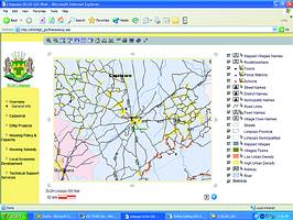
Web shot showing general information of the location sites
The functionality that has been provided is to web-enable the CMIP application with the objective of providing management with a tool to view pertinent information aggregated from the CMIP database on meaningful maps.
Maps are provided which show the location of the CMIP projects. The representation on the map is a symbol that indicates the type and status of project.
Attributes can be displayed that show the following information: project value; category; households affected; status; and planned completion date.
The user selects the project on the map by double clicking on the point to display the attributes.
The GIS can also be used to evaluate various aspects of a proposed project, these include project location, availability of infrastructure, identification of similar projects in the area and location of key institutions/organisations, eg, police stations and clinics.
The implementation team is currently working on Phase 2 of the project and this involves the integration of the following business units with the GIS:
* Housing - policy planning and capacity building.
* Housing - subsidy.
* Technical support services.
* Local economic development.
* Housing - subsidy.
* Technical support services.
* Local economic development.
User requirements interviews have been completed and the functional specifications have been defined. Phase 2 of the project was successfully completed at the end of September.
Phase 3 will involve the integration of the Disaster and Emergency Management Services; Deeds; Land Use Management and Land Survey Services business units with the GIS.
The fourth and final phase will integrate the Development Policy and Planning; Municipal National Relations (MNR); Local Government Administration and Information Management Services business units with system.
Completion of the project is planned for the end of this year and is currently on track to meet the deadline.
For more information contact Pat Thomson, Intergraph Systems Southern Africa, 011 313 1222, pthomson@intergraph.co.za
Others who read this also read these articles
An intelligent, integrated approach
MapIT has crafted a Licensed Partner programme based on the common requirement for highly accurate mapping data[ October 2004 ]
Picture it ...
MarketScope can calculate virtually any demographic scenario for your marketplace, taking into account a variety of factors, including your customer profiles, census information, competitor analysis data and any other set of business-related statistics you wish to evaluate, and visually display the results, arriving at an answer within 30 seconds[ August 2004 ]
Mondi develops advanced GIS business system
Mondi Forests has a truly integrated GIS business system that not only takes care of daily operational requirements, but also facilitates the use of GIS decision-making technology[ June 2003 ]
Implementation of a GIS system in local government
The most cost effective and user friendly way of implementing the MIS system and making it accessible to all authorised officials and Councillors throughout the Municipality was to build a Web application using Bentley Publisher[ April 2003 ]
GIS technology saluted for social and economic contributions
GIS is a powerful analytical tool that integrates spatial (or location) data with associated information, presenting the result in an easy-to-understand, map-based format[ February 2003 ]
ArcGIS Schematics launched
ArcGIS Schematics offers a high degree of flexibility and is not limited by the evolution of the data model and by changing database locations[ February 2003 ]
Building a locations-based service
Before we can start any project, we need to know and understand what the system is going to be used for[ August 2002 ]
Sustainable fisheries and marine conservation in Kenya
A Microsoft Access database is being developed to manage the data[ August 2002 ]
Others who read this also read these news items
Hikers, bikers and urban street pioneers
[ December 2005 ]
Image compression provides post-Katrina aerials within days
[ December 2005 ]
Navigation - the tip of the GIS iceberg
[ October 2005 ]
Fun and affordable in-car navigation
[ October 2005 ]
Cycling on the edge
[ October 2005 ]
Routing made easy
[ August 2005 ]
MapIT expands into West Africa
[ August 2005 ]
Incredible Connection powers navigation tools
[ August 2005 ]
Others who read this also read these regulars
ArcIMS 9.1 Route Server - routing and geocoding
[ October 2005 ]
Enterprise GIS with ArcGIS 9: a comprehensive GIS platform
[ October 2004 ]
GIS in Africa
[ August 2003 ]
Complete logistics and routing solution
[ August 2002 ]
ESRI offers highly integrated GIS solutions
[ April 2002 ]
GIS - the tool to help manage change in the 21st century
[ April/May 2000 ]
GIS software that sets a new standard
[ April/May 2000 ]
Search Site
Subscribe
Previous Issues
Other Technews Publications
Other Technews Buyers Guides
 |  | Copyright c1995-2009 Technews Publishing (Pty) Ltd.. All rights reserved. |