Map happy
1 February 2005
Converting masses of legacy data into geo-relevant digital data can be very time-consuming, yet it represents every scrap of information amassed by generations of local authority planning departments, public utilities, service companies and any other outfit involved in developing and maintaining the country's basic infrastructure.
Because it is spread over thousands, perhaps millions, of hand-drawn plans and documents, converting it into digital information so that it can be used more effectively as part of today's sophisticated GIS solutions involves many man years of patient scrutiny of old maps, land registry documents, sketches and any other arbitrary medium that our ancestors cared to use.
Legacy data is pretty scant information, as well. It merely records the geographical location of a feature, bereft of any other useful information that would benefit the holder of that information. Take street lamps, for instance. Spread over numerous maps for each city, each lamp, which could have been put in place shortly after the introduction of electrical illumination of a city's streets, merely notes the lamp number - if there is one - and where it exists. If that was recorded on a digital map, it could be accompanied by its attributes - the type of lamp, its service history, and the last time the bulb was changed - so that when there is a complaint regarding a street lamp, the relevant service company can pinpoint the problem immediately and send out a van with the necessary tools to solve the problem.
Land boundaries are another case in point. Extracting irregular parcels of land (polylines) from Land Registry records and converting them to digital data is a formidable task. And local authorities that wish to convert a mass of survey data into 3D models of the local terrain - essential for environmental studies and for planning large-scale construction projects - are faced with the tedious task of converting contours into digital vector data. Ordnance Survey sells digital maps that cover every square inch of the country. Great! But these do not include some of the information that the local authorities have in their legacy data. Software is available, however, that simplifies and automates the process - turning a manual task into a smooth operation that can take, literally, years off the process.
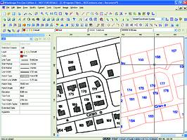
Such a solution is WiseImage Geo, developed by Consistent Software and available from Kinetic Distribution in South Africa. WiseImage Geo is a standalone application specifically developed for the cadastral and GIS markets. Cadastrals refer to the depiction of parcels of lands, including buildings used by the Land Registry.
The software is a comprehensive map-processing tool, using unique raster to vector and raster to contour conversion technology, smart object recognition technology and many other features to simplify the task of converting legacy raster data. WiseImage Geo also allows users to set up custom processing scenarios.
Central to the process is the software's ability to convert raster maps to vector-based digital images. WiseObject can be used to separate text areas and symbols from the image using the software's smart tracing function, or the user can elect to go direct for a quick raster to vector conversion.
The software includes an OCR feature that can pick up text strings at any angle in the drawing, and, like symbols, it can also be trained to recognise new text characters.
WiseImage Geo is based on Consistent Software's WiseImage Pro, a versatile tool for manipulating or extracting any type of data from any document. It is this capability that has been enhanced to include geo-related functionality - providing Studio Script with the means to create complex processing scripts for both GIS and cadastral data. In short, whatever data is held on the map as objects, shapes, lines, or text, WiseImage Geo can be set up to extract it, and to convert it into usable digital data. The software is supplemented with performance enhancing tools, such as the ability to load and display multiple raster images simultaneously, so that they can be worked on in tandem, and a batch processing utility, Batch Studio, that can be set up, like Script Studio, using simple drag and drop visual programming tools. Compatibility with multiple images sources is also vital, hence the support for GeoTIFF, AutoCAD's DEG/DXF, LizardTech MrSID, ER Mapper, plot files, ESRI Shape files, DGN and PDF formats.
For more information contact Kinetic, 031 266 7027, www.kinetic.co.za, www.csoft.com
Others who read this also read these articles
An intelligent, integrated approach
MapIT has crafted a Licensed Partner programme based on the common requirement for highly accurate mapping data[ October 2004 ]
Picture it ...
MarketScope can calculate virtually any demographic scenario for your marketplace, taking into account a variety of factors, including your customer profiles, census information, competitor analysis data and any other set of business-related statistics you wish to evaluate, and visually display the results, arriving at an answer within 30 seconds[ August 2004 ]
Mondi develops advanced GIS business system
Mondi Forests has a truly integrated GIS business system that not only takes care of daily operational requirements, but also facilitates the use of GIS decision-making technology[ June 2003 ]
Implementation of a GIS system in local government
The most cost effective and user friendly way of implementing the MIS system and making it accessible to all authorised officials and Councillors throughout the Municipality was to build a Web application using Bentley Publisher[ April 2003 ]
GIS technology saluted for social and economic contributions
GIS is a powerful analytical tool that integrates spatial (or location) data with associated information, presenting the result in an easy-to-understand, map-based format[ February 2003 ]
ArcGIS Schematics launched
ArcGIS Schematics offers a high degree of flexibility and is not limited by the evolution of the data model and by changing database locations[ February 2003 ]
Building a locations-based service
Before we can start any project, we need to know and understand what the system is going to be used for[ August 2002 ]
Sustainable fisheries and marine conservation in Kenya
A Microsoft Access database is being developed to manage the data[ August 2002 ]
Others who read this also read these news items
Hikers, bikers and urban street pioneers
[ December 2005 ]
Image compression provides post-Katrina aerials within days
[ December 2005 ]
Navigation - the tip of the GIS iceberg
[ October 2005 ]
Fun and affordable in-car navigation
[ October 2005 ]
Cycling on the edge
[ October 2005 ]
Routing made easy
[ August 2005 ]
MapIT expands into West Africa
[ August 2005 ]
Incredible Connection powers navigation tools
[ August 2005 ]
Others who read this also read these regulars
ArcIMS 9.1 Route Server - routing and geocoding
[ October 2005 ]
Enterprise GIS with ArcGIS 9: a comprehensive GIS platform
[ October 2004 ]
GIS in Africa
[ August 2003 ]
Complete logistics and routing solution
[ August 2002 ]
ESRI offers highly integrated GIS solutions
[ April 2002 ]
GIS - the tool to help manage change in the 21st century
[ April/May 2000 ]
GIS software that sets a new standard
[ April/May 2000 ]
Search Site
Subscribe
Previous Issues
Other Technews Publications
Other Technews Buyers Guides
 |  | Copyright c1995-2009 Technews Publishing (Pty) Ltd.. All rights reserved. |