Geosystems Africa officially launched
1 February 2005
October 2004 saw the official launch of Geosystems Africa and the premiere of the System 1200.
Geosystems Africa was formed in June 2004 as an independent company and as the new Leica Geosystems partner for southern Africa. The primary objective of Geosystems Africa is to establish and improve sales, support and technical excellence for the measurement industry in South Africa.
Leica Geosystems recently opened its African Office in South Africa, further reinforcing its commitment.
Leica's standing in the survey industry was reiterated by the launch of System 1200. This innovative system has drawn GPS and Total Station technology onto a common platform. Since both share the same operating system and databases, total interoperability is made possible. This convergence has given birth to cross functionality or as Leica describes it, the X Function.
X Function is not the only achievement, both the GPS and TPS as individual products have made their mark too. GPS1200 is a true 20 Hz system offering incredible accuracy and reliability. This is achieved by Max Accuracy and Smart Check technology that re-computes ambiguity resolution every six seconds to be able to update a user's position every 0,02 seconds. TPS1200 combines traditional infrared EDM with phase-based long range reflectorless at equal accuracy. These options are available as friction-based mechanical, servo driven motorised or unguided robotic with an option to find a prism in under five seconds.
The SR20 caused quite a stir amongst the land and topographical surveyors as an entry-level centimetre accuracy GPS system. This system is perfect for bringing in distant control points and doing terrain surveys with the ease of use coding system onboard.
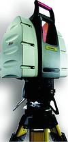
Looking into the future, Leica has redefined 3D laser scanning by launching High Definition Surveying (HDS), a unique new product group that accesses new markets for its existing client base. As the name implies, the scanner captures thousands of points per second to create a cloud of points that recreates a 3D virtual object. The Leica HDS3000 scanner scans a 360° x 270° field of view up to a distance of 200 m at 3 mm accuracy. An onboard camera compiles a mosaicked image, which can then be assigned to the corresponding point in the point cloud to render the true 3D photo realistic scene.
For more information contact Geosystems Africa, 011 691 6700.
Others who read this also read these articles
An intelligent, integrated approach
MapIT has crafted a Licensed Partner programme based on the common requirement for highly accurate mapping data[ October 2004 ]
Picture it ...
MarketScope can calculate virtually any demographic scenario for your marketplace, taking into account a variety of factors, including your customer profiles, census information, competitor analysis data and any other set of business-related statistics you wish to evaluate, and visually display the results, arriving at an answer within 30 seconds[ August 2004 ]
Mondi develops advanced GIS business system
Mondi Forests has a truly integrated GIS business system that not only takes care of daily operational requirements, but also facilitates the use of GIS decision-making technology[ June 2003 ]
Implementation of a GIS system in local government
The most cost effective and user friendly way of implementing the MIS system and making it accessible to all authorised officials and Councillors throughout the Municipality was to build a Web application using Bentley Publisher[ April 2003 ]
GIS technology saluted for social and economic contributions
GIS is a powerful analytical tool that integrates spatial (or location) data with associated information, presenting the result in an easy-to-understand, map-based format[ February 2003 ]
ArcGIS Schematics launched
ArcGIS Schematics offers a high degree of flexibility and is not limited by the evolution of the data model and by changing database locations[ February 2003 ]
Building a locations-based service
Before we can start any project, we need to know and understand what the system is going to be used for[ August 2002 ]
Sustainable fisheries and marine conservation in Kenya
A Microsoft Access database is being developed to manage the data[ August 2002 ]
Others who read this also read these news items
Hikers, bikers and urban street pioneers
[ December 2005 ]
Image compression provides post-Katrina aerials within days
[ December 2005 ]
Navigation - the tip of the GIS iceberg
[ October 2005 ]
Fun and affordable in-car navigation
[ October 2005 ]
Cycling on the edge
[ October 2005 ]
Routing made easy
[ August 2005 ]
MapIT expands into West Africa
[ August 2005 ]
Incredible Connection powers navigation tools
[ August 2005 ]
Others who read this also read these regulars
ArcIMS 9.1 Route Server - routing and geocoding
[ October 2005 ]
Enterprise GIS with ArcGIS 9: a comprehensive GIS platform
[ October 2004 ]
GIS in Africa
[ August 2003 ]
Complete logistics and routing solution
[ August 2002 ]
ESRI offers highly integrated GIS solutions
[ April 2002 ]
GIS - the tool to help manage change in the 21st century
[ April/May 2000 ]
GIS software that sets a new standard
[ April/May 2000 ]
Search Site
Subscribe
Previous Issues
Other Technews Publications
Other Technews Buyers Guides
 |  | Copyright c1995-2009 Technews Publishing (Pty) Ltd.. All rights reserved. |