Guided by satellite to the beet field - a GPS-based GIS for the sugar beet harvest logistic is just the beginning
1 April 2000
The innovative product is a result of intensive cooperation between PROGIS as well as the German Agricultural Co-operative (Maschinenring) and the German software house Landdata Eurosoft.
In the past, the machine drivers received printed lists with their daily work plan, now they navigate to the beet fields with the help of satellites and Geographic Information Systems (GIS). The pilot project was developed at the Dillingen Agricultural Cooperative and was presented together with ProGIS professionals to the heads of the Südzucker organisation. The new system is set to be used in the upcoming sugar beet campaign (Autumn 2000).
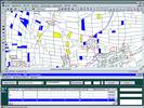
Until now the result of the harvest had to be sent back to the Agricultural Co-operative by mail. "The whole procedure was very time and work intensive", says the Manager of the Bavarian Agricultural Co-operative, Erwin Ballis. The sugar beet fields will now be registered into WinGIS with the click of a mouse. At the Dillingen Agricultural Cooperative 800 fields were entered in just two days, reports Manager Dieter Ott. "In this way, planning can be done directly on the monitor, with direct transmittal to the harvester by mobile phone", explains Ballis. So the driver can see on the monitor which field is the next in line. The headquarters has an online overview of the settled areas.
As a result of the entire installation the user receives a complete geographical information system, the so-called ZR-WinGIS application, in which the beets are registered and allocated automatically to the ZR-Win database on an individual map. After registration of the required beets for the campaign, the rooter and loader routes are planned on the central ZR-WinGIS system. Then the tours can be individually stored for each rooter and loader and transferred by telephone to the appropriate rooter, also shown graphically. The rooter, respectively the loader machine, gets its daily tour already before work starts. The driver can determine his current position and head for the indicated beets.
On arrival of the rooter at the beet to be cultivated, a touchscreen coupled to an on-board computer provides the means to enter the status: 'start work' and 'work finished'. This information is transferred to the central office just by a button click. So the central office is permanently aware of the current work status.
By adding the respective beet layer, a symbol is placed automatically on this position and transmitted via GSM to the central office. This is an important information for the central controlled loading machine and with it for the removal of the beets. After completion of the work, the on-board computer produces and prints a delivery note, containing important information, that is also transfered electronically, and is used as a base for accounting and other evaluation purposes.
ProGIS Software, Austria
(0943) 4242 26332
Others who read this also read these articles
An intelligent, integrated approach
MapIT has crafted a Licensed Partner programme based on the common requirement for highly accurate mapping data[ October 2004 ]
Picture it ...
MarketScope can calculate virtually any demographic scenario for your marketplace, taking into account a variety of factors, including your customer profiles, census information, competitor analysis data and any other set of business-related statistics you wish to evaluate, and visually display the results, arriving at an answer within 30 seconds[ August 2004 ]
Mondi develops advanced GIS business system
Mondi Forests has a truly integrated GIS business system that not only takes care of daily operational requirements, but also facilitates the use of GIS decision-making technology[ June 2003 ]
Implementation of a GIS system in local government
The most cost effective and user friendly way of implementing the MIS system and making it accessible to all authorised officials and Councillors throughout the Municipality was to build a Web application using Bentley Publisher[ April 2003 ]
GIS technology saluted for social and economic contributions
GIS is a powerful analytical tool that integrates spatial (or location) data with associated information, presenting the result in an easy-to-understand, map-based format[ February 2003 ]
ArcGIS Schematics launched
ArcGIS Schematics offers a high degree of flexibility and is not limited by the evolution of the data model and by changing database locations[ February 2003 ]
Building a locations-based service
Before we can start any project, we need to know and understand what the system is going to be used for[ August 2002 ]
Sustainable fisheries and marine conservation in Kenya
A Microsoft Access database is being developed to manage the data[ August 2002 ]
Others who read this also read these news items
Hikers, bikers and urban street pioneers
[ December 2005 ]
Image compression provides post-Katrina aerials within days
[ December 2005 ]
Navigation - the tip of the GIS iceberg
[ October 2005 ]
Fun and affordable in-car navigation
[ October 2005 ]
Cycling on the edge
[ October 2005 ]
Routing made easy
[ August 2005 ]
MapIT expands into West Africa
[ August 2005 ]
Incredible Connection powers navigation tools
[ August 2005 ]
Others who read this also read these regulars
ArcIMS 9.1 Route Server - routing and geocoding
[ October 2005 ]
Enterprise GIS with ArcGIS 9: a comprehensive GIS platform
[ October 2004 ]
GIS in Africa
[ August 2003 ]
Complete logistics and routing solution
[ August 2002 ]
ESRI offers highly integrated GIS solutions
[ April 2002 ]
GIS - the tool to help manage change in the 21st century
[ April/May 2000 ]
GIS software that sets a new standard
[ April/May 2000 ]
Search Site
Subscribe
Previous Issues
Other Technews Publications
Other Technews Buyers Guides
 |  | Copyright c1995-2009 Technews Publishing (Pty) Ltd.. All rights reserved. |