Accurate electrical network plans are a mouse click away
1 February 2001
A prime municipal function is the effective and ongoing management of the various utility networks. Of these, the most complex is the electrical network. It is also one of the most critical, particularly in industrial areas and central business districts where power outages are not only an inconvenience but also negatively impact productivity.
According to Chris Tolken, Managing Director of Munsys Technologies, there are two main types of information necessary for effective network management. "Firstly, accurate information about the physical location of all the elements in the network and, secondly, schematic representations of how the network connects. Most municipalities have adequate schematics but readily available location information is often a problem."
Accurate plans are important for maintenance purposes and in terms of being able to notify other municipal departments where cables actually are in the ground. Says Tolken, "For example, if the water department goes out to fix a burst pipe they may not know whether electrical cables are in close proximity and, as a result, accidental damage to cabling can easily occur. A large proportion of electrical network damage is due to the inadvertent actions of workmen and other contractors. The advantage of accurate, readily available plans in these instances is obvious."
MunSys' Electricity Management System (EMS) is a network management tool that facilitates the fast, easy production of map books and working drawings. With EMS the initial capture of electrical data takes about one quarter of the time it would take using a traditional system and, most importantly, the system maintains the network's connectivity by storing it automatically as cables are placed during data capture.
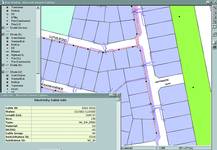
Typical output from EMS
"Most municipalities rely on paper plans and, even though today many of these are CAD generated, they contain little intelligence regarding connectivity. Many municipal personnel will be all too familiar with the time-consuming, difficult task of searching extensive drawing archives for a particular set of plans that possibly do not even exist," says Tolken. "Using EMS completely transforms this process. For example, with traditional methods, establishing where a particular substation feeds from and feeds to may necessitate a lengthy search involving many different plans. With EMS, a click on that particular substation will immediately reveal all the relevant connectivity detail which can then be printed out in one easy step."
Based on proven Oracle and Autodesk technology, MunSys is a suite of six fully integrated packages, including EMS, which cover the full spectrum of municipal spatial data requirements. MunSys was created specifically for local government use and the system is based on open technologies.
"It is extremely easy to use, requires very little training and all the applications share a common database," says Tolken. "This means that all the information from each department is readily available to anyone who needs to view it and accurate plans and map books can be printed out as required."
MunSys Technologies
(011) 781 1224
Others who read this also read these articles
An intelligent, integrated approach
MapIT has crafted a Licensed Partner programme based on the common requirement for highly accurate mapping data[ October 2004 ]
Picture it ...
MarketScope can calculate virtually any demographic scenario for your marketplace, taking into account a variety of factors, including your customer profiles, census information, competitor analysis data and any other set of business-related statistics you wish to evaluate, and visually display the results, arriving at an answer within 30 seconds[ August 2004 ]
Mondi develops advanced GIS business system
Mondi Forests has a truly integrated GIS business system that not only takes care of daily operational requirements, but also facilitates the use of GIS decision-making technology[ June 2003 ]
Implementation of a GIS system in local government
The most cost effective and user friendly way of implementing the MIS system and making it accessible to all authorised officials and Councillors throughout the Municipality was to build a Web application using Bentley Publisher[ April 2003 ]
GIS technology saluted for social and economic contributions
GIS is a powerful analytical tool that integrates spatial (or location) data with associated information, presenting the result in an easy-to-understand, map-based format[ February 2003 ]
ArcGIS Schematics launched
ArcGIS Schematics offers a high degree of flexibility and is not limited by the evolution of the data model and by changing database locations[ February 2003 ]
Building a locations-based service
Before we can start any project, we need to know and understand what the system is going to be used for[ August 2002 ]
Sustainable fisheries and marine conservation in Kenya
A Microsoft Access database is being developed to manage the data[ August 2002 ]
Others who read this also read these news items
Hikers, bikers and urban street pioneers
[ December 2005 ]
Image compression provides post-Katrina aerials within days
[ December 2005 ]
Navigation - the tip of the GIS iceberg
[ October 2005 ]
Fun and affordable in-car navigation
[ October 2005 ]
Cycling on the edge
[ October 2005 ]
Routing made easy
[ August 2005 ]
MapIT expands into West Africa
[ August 2005 ]
Incredible Connection powers navigation tools
[ August 2005 ]
Others who read this also read these regulars
ArcIMS 9.1 Route Server - routing and geocoding
[ October 2005 ]
Enterprise GIS with ArcGIS 9: a comprehensive GIS platform
[ October 2004 ]
GIS in Africa
[ August 2003 ]
Complete logistics and routing solution
[ August 2002 ]
ESRI offers highly integrated GIS solutions
[ April 2002 ]
GIS - the tool to help manage change in the 21st century
[ April/May 2000 ]
GIS software that sets a new standard
[ April/May 2000 ]
Search Site
Subscribe
Previous Issues
Other Technews Publications
Other Technews Buyers Guides
 |  | Copyright c1995-2009 Technews Publishing (Pty) Ltd.. All rights reserved. |